Key Points
- A “forgotten canal” that once ran through south-east London, the Grand Surrey Canal, has been revived in public discussion by a viral TikTok video from London‑history creator History Hun (@historyhun).
- The Grand Surrey Canal, originally opened between 1807 and 1809, linked the Surrey Commercial Docks in Rotherhithe with Camberwell and later Peckham, and was intended to stretch as far south as Epsom in Surrey.
- As reported by Southwark News, the canal operated for over 167 years, supplying south London with timber, limestone, and other goods before decline set in after the Second World War.
- By the 1960s and 1970s, the canal was largely drained and filled in, with its former route now forming parts of modern roads, parks, and walking paths, including Surrey Canal Road, Burgess Park, and the Surrey Canal Path.
- The London Museum notes that the Grand Surrey Canal was the first London canal to employ dedicated “bank rangers” as canal‑side police, and today its traces are embedded in street names, bridges, and green spaces across Southwark.
- History Hun’s TikTok clip helps contemporary audiences see how the buried canal continues to shape Peckham’s estates, parks, and even Overground‑adjacent infrastructure, sparking fresh local interest in the area’s industrial past.
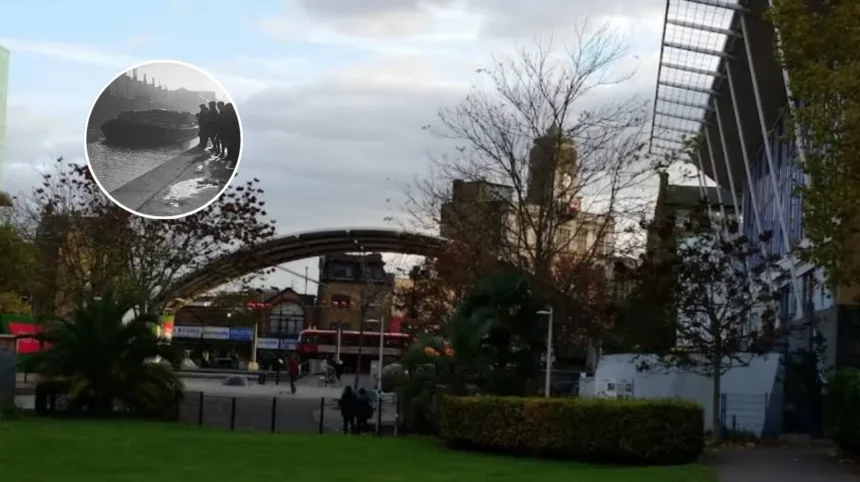
South London (South London News) April 11, 2026 –What buried waterway once stitched together Rotherhithe, Camberwell and Peckham, yet now lies invisible beneath roads and park paths? It is the Grand Surrey Canal, a “forgotten canal” of south east London that has recently resurfaced in public memory thanks to a viral TikTok video from London‑history creator History Hun (@historyhun). Her clip, which zooms along the canal’s former route, highlights how this vanished industrial artery still quietly shapes Peckham’s layout, from housing estates and squares to train‑line corridors and the London Overground network.
- Key Points
- How did the canal grow from a parliamentary project into a working artery for south London?
- Why did the Grand Surrey Canal disappear from view?
- How is the canal’s legacy visible today?
- What role does the viral TikTok video play in this rediscovery?
- Background of the Grand Surrey Canal development
- Prediction for how this development affects south London communities
The Grand Surrey Canal, which opened between 1807 and 1809, was conceived as a link between the Surrey Commercial Docks at Rotherhithe and the expanding suburbs of south London, with the original ambition to stretch as far as Epsom in Surrey. Southwark News explains that the canal’s core section in the borough ran for about four miles, connecting Surrey Commercial Docks to Camberwell and then Peckham, forming a key transport route for timber, building materials, and other cargo.
The London Museum, in its overview of “London’s lost canals”, notes that the waterway was primarily used to transport timber and limestone for the construction trade and that it was the first canal in London to employ “bank rangers” – a form of canal‑side constabulary.
How did the canal grow from a parliamentary project into a working artery for south London?
Southwark News reports that the Grand Surrey Canal Company was authorised by an Act of Parliament in 1801, with engineer Ralph Dodd proposing a route from the Thames at Rotherhithe southward through the suburbs.
The first branch to the Old Kent Road opened by 1807; by 1810 the canal had reached as far as the Camberwell Basin, now part of Burgess Park; and by 1826 a branch was completed from Glengall Wharf (today the site of a community garden) to the Peckham Basin, now Peckham Square.
These stages turned the canal into a hub for barge traffic, supplying everything from timber to “toys” to communities across Southwark.
What did canal‑life in south London look like for traders and residents? Southwark News describes how spacious sailing barges, often around 30 metres long and six metres wide, carried cargo such as bibles, limestone and imported timber. Much of the timber arrived from Scandinavia, the Baltics and Canada, which is why nearby docks later took names such as Russia Dock, Greenland Dock and Canada Water.
The canal’s shallow‑water design allowed barges to operate with a draft of just one metre, and horse‑drawn barges were used to move goods under low bridges toward Camberwell and Peckham. By the early 20th century, the canal’s register reportedly listed around 20,000 barges, a sign of its peak importance as a freight corridor.
How did the canal shape the social life of south London communities? Oral‑history material collected by the Friends of Burgess Park, as cited by Southwark News, shows that children in Bermondsey, Rotherhithe and Peckham used the canal for informal play long after its commercial decline. One elderly resident recalled being able to access the banks and play in the water, while others described making makeshift rafts from salvaged doors and timber left over from bomb‑damaged buildings.
“We could get on the banks of the canal and we used to play in there,”
the person told the project. Another recollection notes that children fitted polystyrene inside wooden pallets to create more stable rafts, while many remember catching stickleback fish in the still water.
Yet the canal was also remembered as a place of danger. Southwark News quotes another local contributor who pointed out that “canals have steep sides” and that falling in could be life‑threatening, especially for children.
“If your mum and dad knew you were down there you’d be in trouble,”
the person added. These accounts underscore how the waterway straddled both work and leisure, danger and adventure, for generations of south Londoners.
Why did the Grand Surrey Canal disappear from view?
Southwark News explains that the canal’s role diminished as railways and road networks expanded, offering faster and more flexible freight options. Neglect and pollution further eroded the canal’s reputation, and by 1960 much of it had been drained. The final blow came in 1970, when the dock was permanently closed to commercial traffic; by 1974 the canal was entirely drained to prevent accidents.
The London Museum notes that the canal was filled in during the decades following the Second World War and repurposed as roads and green spaces, a pattern seen with many lost London canals.
How is the canal’s legacy visible today?
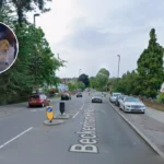
Southwark News highlights that the former canal bed is now traceable in Southwark’s street layout. The section between South Bermondsey and Deptford became Surrey Canal Road, linking Ilderton Road with Trundleys Road, while the Peckham branch evolved into the Surrey Canal Path, with the old canal head at what is now Peckham Square (the site of the Peckham Arch).
The canal’s Camberwell branch joined the Camberwell Basin, part of which became Burgess Park, where the so‑called “Bridge to Nowhere” stands as a remnant of a crossing that once spanned open water.
The London Museum adds that the Grand Surrey Canal’s imprint can be found in street and park names and in the positioning of transport corridors, including the routes used by modern rail and bus services.
What role does the viral TikTok video play in this rediscovery?
The clip by History Hun, shared on TikTok under the handle @historyhun, uses digital mapping to retrace the canal’s path across Peckham, illustrating how former wharves, basins and industrial margins now sit beneath estates, parks and Overground‑adjacent infrastructure.
As the video circulates, it brings the canal’s industrial past into conversation alongside Peckham’s contemporary identity, including references to nearby cultural figures such as rapper Giggs and the wider story of south London’s evolving built environment.
History Hun’s caption, visible on the TikTok post, frames the canal as a hidden layer of Peckham’s geography, linking forgotten industrial infrastructure to the way the neighbourhood looks and functions today.
Background of the Grand Surrey Canal development
The Grand Surrey Canal was one of several early‑19th‑century canal projects born out of what historians often describe as the “Golden Age of British Canals” between the 1770s and 1830s. As Southwark News notes, that period followed the success of the Aire & Calder Navigation, which showed investors that canal‑based freight could be highly profitable despite high construction costs.
Ralph Dodd’s 1799 proposal for a canal from Rotherhithe through south London suburbs was part of this wave, backed by an 1801 Act of Parliament and the creation of the Company of Proprietors of the Grand Surrey Canal.
Unlike longer‑running canals that survived into the modern leisure era, the Grand Surrey Canal never reached its planned terminus near Epsom. It did, however, extend gradually through Southwark, forming an industrial spine that fed the docks at Rotherhithe with goods bound for the capital’s expanding suburbs. The London Museum emphasises that the canal was emblematic of London’s shift from river‑centric trade to a more complex network of docks, canals and later railways and roads.
By the mid‑20th century, when the canal was closed and filled in, its route was absorbed into the city’s expanding road and green‑space network, with Southwark Borough Council and the Port of London Authority overseeing the transition.
Prediction for how this development affects south London communities
As renewed interest in the Grand Surrey Canal spreads through social‑media‑driven history‑content formats such as TikTok, local residents and visitors in south London may increasingly view familiar streets, parks and railway corridors through a historical lens. Southwark News’s emphasis on the canal’s role in shaping Peckham Square, the Surrey Canal Path, Burgess Park and surrounding road layouts suggests that this rediscovery could influence how people interpret everyday infrastructure, from walking routes to Overground‑adjacent junctions.