Lambeth’s Thames Path is one of the most accessible ways to experience the River Thames in central London. The riverside route connects major landmarks, bridges, cultural venues, historic sites, open spaces and transport hubs across the borough. It works for short walks, longer riverside outings and structured sightseeing itineraries.
- Where does the Thames Path run through Lambeth?
- Which landmarks can visitors see along Lambeth’s Thames Path?
- How can visitors understand the history of Lambeth’s Thames Path?
- What is the best walking route for a first visit?
- Which parks and green spaces can visitors combine with the Thames Path?
- How can visitors combine the Thames Path with museums and cultural attractions?
- How can visitors use public transport with the Lambeth Thames Path?
- Is the Lambeth Thames Path suitable for families and accessible walking?
- When is the best time to walk the Lambeth Thames Path?
- How can visitors plan a complete Lambeth Thames Path itinerary?
- Why is Lambeth’s Thames Path important for exploring London?
The Thames Path is a National Trail running for 185.2 miles (298 km) from the River Thames source in the Cotswolds to Woolwich in London. It is mostly flat, well waymarked and suitable for anything from a short afternoon walk to a much longer walking trip.
Lambeth occupies an important central section of the London route. Its riverside landscape includes Westminster Bridge, Lambeth Bridge, the South Bank, Albert Embankment and Vauxhall. Visitors can combine walking with museums, theatres, gardens, restaurants, river transport and historic architecture.
Where does the Thames Path run through Lambeth?
The Thames Path follows Lambeth’s southern bank of the River Thames through central London, linking Westminster Bridge, the South Bank, Lambeth Bridge, Albert Embankment and Vauxhall before continuing towards neighbouring riverside districts.
The exact experience changes as the river passes different parts of Lambeth. The eastern section around Waterloo and the South Bank has a dense concentration of cultural attractions, restaurants and public spaces. Further west, the environment becomes more focused on embankments, residential areas, bridges, historic buildings and riverside development.
Visit London describes South Bank and Waterloo as the area between Lambeth Bridge and Blackfriars Bridge on the south side of the Thames. The area includes major visitor attractions and pedestrianised riverside routes.
For visitors, this means the Lambeth section works particularly well as a flexible walking route rather than a single fixed excursion. A traveller can start near Westminster Bridge, walk towards Lambeth Bridge and continue west towards Vauxhall.
The National Trail itself continues far beyond Lambeth. The complete route passes through rural landscapes, historic towns and London before reaching Woolwich. Its London section therefore forms only one part of a much longer national walking route.
Visitors should distinguish between the Thames Path National Trail and other riverside paths. The National Trail is the officially designated long-distance route. Local streets, promenades and connecting paths can provide useful access to attractions but do not necessarily form part of the designated trail.
Which landmarks can visitors see along Lambeth’s Thames Path?
Visitors can see Westminster Bridge, the London Eye, Lambeth Palace, Lambeth Bridge, St Thomas’ Hospital, Albert Embankment, Vauxhall Bridge and Tate Britain from or close to the riverside route.
The concentration of landmarks makes Lambeth particularly useful for visitors who want to combine walking with sightseeing.
Starting around Westminster Bridge gives immediate views towards the Palace of Westminster and Big Ben. The bridge itself connects Westminster on the north bank with the South Bank and provides a major pedestrian crossing.
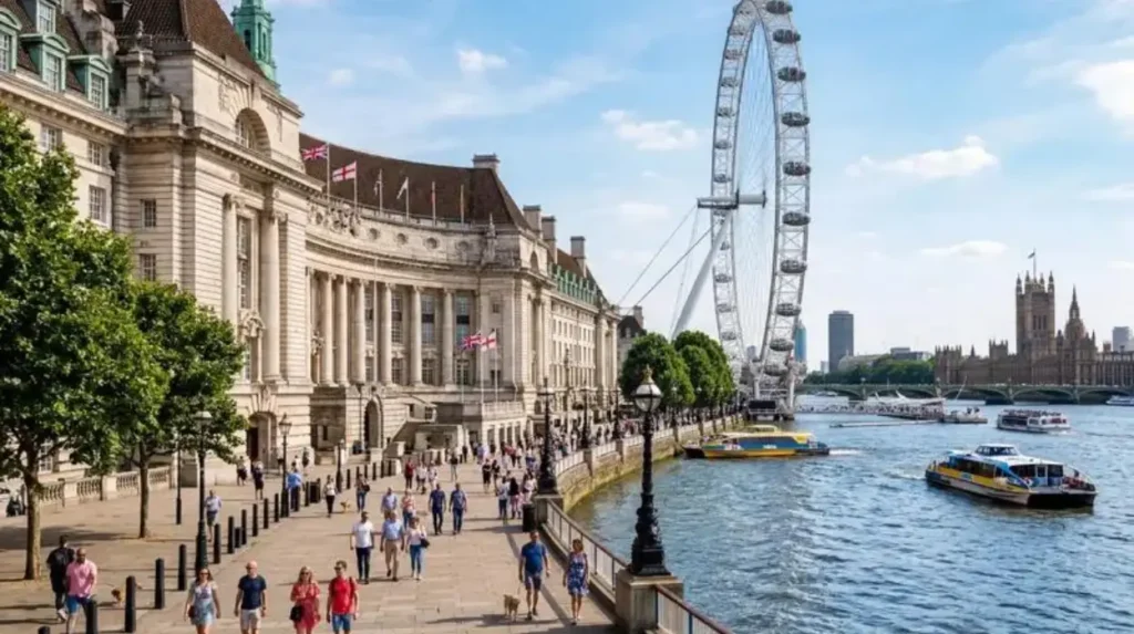
The London Eye stands beside the river on the South Bank. It forms one of the most recognisable landmarks in this part of London and sits close to the pedestrian riverside route.
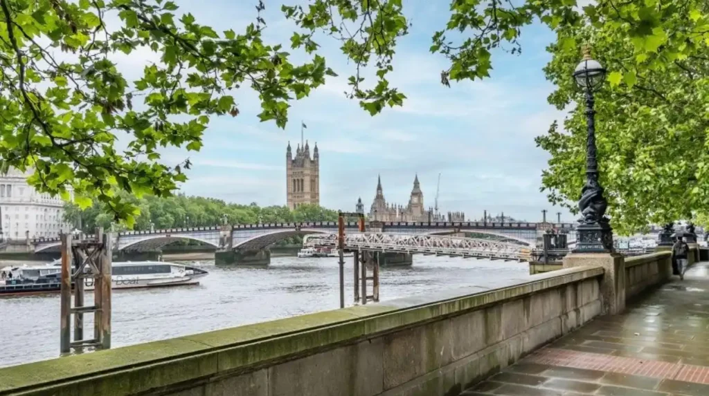
Further west, Lambeth Bridge provides another important crossing. Visit London notes that Lambeth Bridge offers views towards the Houses of Parliament, Big Ben and the London Eye.
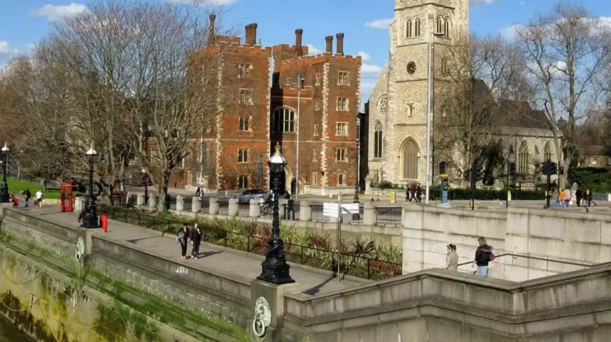
Lambeth Palace is another significant landmark. It has served as the London residence of the Archbishop of Canterbury and is closely associated with the history of Lambeth. The nearby Archbishop’s Park occupies land that was once part of the palace grounds.
St Thomas’ Hospital occupies a prominent position opposite the Palace of Westminster. Its riverside setting creates another distinctive section of the walk, particularly around Westminster Bridge and the London Eye.
Continuing west brings visitors towards Albert Embankment. This section has a different character from the busy South Bank. The riverside combines historic buildings, modern residential development, public spaces and views across the Thames.
Tate Britain is located at Millbank, immediately beyond Lambeth’s western riverside area. The gallery is an important cultural stop for visitors extending their walk towards Chelsea and Pimlico. Tate lists its Tate Britain location as Millbank, London SW1P 4RG.
The sequence of landmarks allows visitors to build a route around specific interests rather than simply walking from one end to another.
How can visitors understand the history of Lambeth’s Thames Path?
The Thames Path crosses a riverside landscape shaped by medieval religious institutions, river transport, industrial development, Victorian infrastructure and modern regeneration, with Lambeth Palace and historic embankments providing visible connections to earlier periods.
The River Thames has been central to London’s development for centuries. Its banks supported transportation, trade, religious institutions, industry and urban expansion.
Lambeth Palace provides one of the strongest historical connections along the Lambeth riverside. The Archbishop of Canterbury’s London residence has been associated with the area for centuries, while Archbishop’s Park preserves part of the former palace grounds. The public park opened in 1901.
The development of the modern Thames Path itself is also relatively recent. The route emerged from efforts to restore and connect sections of historic riverside towpaths. The National Trails history records cooperation between the Ramblers, the River Thames Society, local campaign groups, landowners and authorities. The Thames Path was formally inaugurated in 1996.
As you explore the modern site, you are crossing land with a deep heritage. Read about the full to understand its origins.
The Victorian period transformed large sections of the Thames through engineering, embankment construction, bridges, hospitals, transport infrastructure and urban development. Many riverside structures visible today reflect that period of rapid growth.
Lambeth’s bridges also demonstrate changing approaches to river transport. Lambeth Bridge and Vauxhall Bridge connect the borough with the north bank and provide important pedestrian and road connections. Vauxhall Bridge was designed by Sir Alexander Binnie and links Pimlico with Vauxhall.
Historical interpretation therefore forms an important part of the walk. The riverfront is not simply open space. It is a corridor containing evidence of London’s religious, political, medical, commercial and transport history.
What is the best walking route for a first visit?
A first Lambeth Thames Path walk works well from Westminster Bridge through the South Bank and Lambeth Bridge towards Albert Embankment, allowing visitors to combine major landmarks, riverside views, cultural venues, parks and public transport connections.
A practical first route starts around Westminster Bridge. This location has strong transport connections and places several major landmarks within immediate walking distance.
From Westminster Bridge, follow the riverside east or west according to the planned itinerary. For a Lambeth-focused walk, heading south along the South Bank brings the route through one of London’s busiest cultural districts.
The riverside between Westminster and Lambeth Bridge contains major attractions and public spaces. The South Bank Centre, National Theatre, London Eye and surrounding riverside venues create frequent opportunities to stop without leaving the main sightseeing area.
Lambeth Bridge provides a natural midpoint. Visitors can cross the river here if they want to create a shorter circular walk. Staying on the Lambeth side allows the route to continue west towards Albert Embankment.
The Albert Embankment section offers a more linear riverside experience. The council identifies Albert Embankment Gardens as a chain of small open spaces running between Vauxhall and Waterloo along the River Thames.
Visitors who continue towards Vauxhall can use Vauxhall Bridge as another crossing point. This creates options for returning to the north bank or connecting with Vauxhall’s transport network.
A first-time visitor should therefore treat the route as a sequence of connected sections rather than a single compulsory walk. A short outing can focus on Westminster Bridge to Lambeth Bridge. A longer walk can continue through Albert Embankment towards Vauxhall.
Which parks and green spaces can visitors combine with the Thames Path?
Visitors can combine the riverside walk with Archbishop’s Park, Albert Embankment Gardens and other nearby public spaces, creating breaks for rest, recreation, views and nature without travelling far from the Thames.
Lambeth has an extensive public open-space network. The council currently lists more than 78 parks, commons and other public open spaces across the borough.
Archbishop’s Park is particularly relevant to a Thames Path itinerary. It sits close to Lambeth Palace and provides a substantial green space within the central London environment. The park contains mature trees, wildlife habitats, sports facilities, a children’s playground and community gardening features.
The park also has historical significance because its land formed part of Lambeth Palace’s former grounds. This makes it useful for visitors interested in both landscape and heritage.
Albert Embankment Gardens provide another riverside green-space connection. Their linear arrangement makes them suitable for short pauses during a longer walk.
Lambeth Council manages a broad network of parks and open spaces with facilities ranging from wildlife areas and quiet sitting areas to cafés, toilets, playgrounds, sports facilities and community gardens.
Visitors should check individual opening times before planning a late-evening route through a park. Lambeth Council states that its parks and open spaces close at night, with official closing times generally set around 15 minutes before dusk and varying throughout the year.
This distinction matters because the riverside path and an individual park do not necessarily have identical access arrangements.
How can visitors combine the Thames Path with museums and cultural attractions?
Visitors can combine the Thames Path with the Southbank Centre, National Theatre, London Eye and Tate Britain, creating a walking itinerary that connects riverside scenery with art, performance, architecture and major London attractions.
The South Bank is one of the strongest cultural sections of the Lambeth riverside. Visit London identifies the National Theatre, Southbank Centre and BFI IMAX among its major cultural destinations.
The Southbank Centre occupies a prominent position beside the Thames. Its venues support performances, exhibitions and cultural events, making it a useful stop for visitors who want an indoor activity during a walking day.
The National Theatre is also positioned close to the river. Its location allows visitors to combine a daytime riverside walk with an evening performance.
The London Eye provides another major attraction immediately beside the Thames. Visitors can use the surrounding riverside as an access route before or after a flight on the observation wheel.
Tate Britain offers a different cultural experience. Located at Millbank, it provides access to British art and creates a useful endpoint for visitors extending a Lambeth riverside itinerary westwards.
These attractions also make the Thames Path suitable for different travel schedules. A tourist with half a day can select one cultural venue. A full-day visitor can combine several stops with the walk.
For digital nomads and business travellers, the cultural venues and surrounding cafés provide opportunities to divide sightseeing into shorter sections. The pedestrianised South Bank also provides a practical environment for walking between meetings, transport hubs and scheduled activities. Visit London describes the South Bank and Waterloo riverside as wide, flat and pedestrian-friendly.
How can visitors use public transport with the Lambeth Thames Path?
Visitors can combine walking with Underground, railway, bus and river services at Waterloo, Vauxhall, Westminster and nearby central London transport hubs, making it easy to shorten, extend or reposition a Thames Path itinerary.
Transport flexibility is one of the main practical advantages of the Lambeth riverside.
Waterloo is one of the most important transport points for the South Bank. Visit London identifies Waterloo and Southwark as the nearest Tube stations for South Bank and Waterloo, with Waterloo served by the Jubilee, Northern, Bakerloo and Waterloo & City lines.
Vauxhall provides another major interchange towards the western side of the Lambeth riverside. Its position close to Vauxhall Bridge makes it useful for visitors ending a walk around Albert Embankment.
Westminster provides another strategic access point. Visitors can begin around Westminster Bridge and then follow the Thames southwards into Lambeth.
River transport provides another way to structure a Thames itinerary. London has numerous river piers serving river bus services and sightseeing boats. Visit London lists Westminster Millennium, Embankment and other central piers among the city’s river transport network.
This creates a useful walking-and-boat combination. Visitors can walk one section and use a river service for another section rather than completing the entire journey on foot.
River cruises also operate from central piers, including Westminster Pier, with nearby access to Big Ben, the London Eye and the Houses of Parliament.
Transport should therefore be treated as part of the route design rather than simply a way to reach the start point.
Is the Lambeth Thames Path suitable for families and accessible walking?
The central Lambeth riverside is well suited to visitors seeking a relatively flat urban walk, while individual facilities, crossings, parks and venues have different accessibility arrangements that should be checked before travelling.
The Thames Path is described by National Trails as a mostly flat route that is easy to navigate and well waymarked.
South Bank and Waterloo are particularly convenient for straightforward urban walking. Visit London describes their riverside walkways as wide and flat and highlights accessibility information for the area.
Families can combine walking with attractions and open spaces. Archbishop’s Park contains a large children’s playground, sports facilities and wildlife habitats, making it a practical break from the riverside route.
Accessibility still requires route-specific planning. A riverside promenade, bridge, park entrance, attraction and railway station each have different physical layouts.
Visitors using wheelchairs, mobility scooters or pushchairs should check current access information for their chosen start point, attractions and transport stations before travelling.
Families should also account for the urban environment. The Lambeth section contains busy pedestrian areas, road crossings, bridges and major visitor attractions. Staying close to marked pedestrian routes provides a more controlled itinerary.
The route is also suitable for shorter walks. Visitors do not need to complete a large distance to experience the main riverside landmarks.
When is the best time to walk the Lambeth Thames Path?
The Lambeth Thames Path can be explored throughout the year, but daylight hours, weather, park opening times, visitor levels and scheduled events affect the most practical time for a riverside walk.
Spring, summer and early autumn provide longer daylight hours for sightseeing. They also make it easier to combine the river walk with parks and outdoor public spaces.
The National Trails guidance identifies spring through autumn as the strongest general period for experiencing the Thames Path, with April and May particularly useful for observing river wildlife and April to September suitable for wildflowers.
Lambeth’s urban section differs from rural stretches of the National Trail because its main attractions operate within a dense city environment. Visitors therefore need to consider opening times for museums, parks, cafés and cultural venues.
Summer brings longer evenings but also higher visitor activity around major attractions. An early start provides more time for sightseeing before the busiest periods.
Winter offers shorter daylight hours. Visitors planning a winter walk should prioritise open attractions and transport connections and avoid relying on late access to parks.
Weather also affects the experience. Rain, strong winds and cold temperatures make riverside walking less comfortable, while bright weather increases demand around major attractions.
A practical approach is to plan the walk around the attraction rather than the other way around. Visitors attending a performance at the National Theatre, for example, can walk along the South Bank beforehand and then continue directly to the venue.
Explore More Area Guide
Short Excursions in Lambeth: Best Places to Visit
Where Should First-Time Visitors Begin Exploring Lambeth?
How can visitors plan a complete Lambeth Thames Path itinerary?
A complete itinerary should identify a start point, walking direction, landmark stops, food or rest breaks, transport alternatives and an end point, allowing visitors to adjust the distance without losing the main Lambeth riverside experience.
A half-day itinerary can start at Westminster Bridge, continue along the South Bank, stop at the London Eye or Southbank Centre and finish around Lambeth Bridge.
A longer itinerary can continue west from Lambeth Bridge towards Albert Embankment and Vauxhall. This version provides more riverside scenery and a broader view of Lambeth’s relationship with the Thames.
Visitors interested in heritage can include Lambeth Palace and Archbishop’s Park. The park’s connection with the former palace grounds gives the walking route additional historical context.
Art-focused visitors can include Tate Britain at Millbank. This creates a route that connects the South Bank’s contemporary cultural institutions with a major collection of British art.
Families can prioritise shorter walking sections combined with playgrounds and attractions. Archbishop’s Park provides a useful green-space stop, while the South Bank provides several major visitor attractions within a concentrated area.
Business travellers with limited free time can use Waterloo, Westminster or Vauxhall as start and end points. This reduces unnecessary travel and allows a riverside walk to fit around appointments.
Digital nomads can divide the experience into shorter segments around cafés, cultural venues and public spaces, although work facilities and seating vary by venue.
Visitors should also use the official Thames Path map when planning longer walks. National Trails provides an interactive map with information on route lines, accommodation, food and drink, transport and water points.
The strongest planning principle is flexibility. Lambeth’s riverside has enough transport connections and attractions to support short walks, extended excursions and circular itineraries.
Why is Lambeth’s Thames Path important for exploring London?
Lambeth’s Thames Path connects river scenery with London’s political, cultural, architectural and historical landmarks, providing a continuous walking framework through a central part of the capital that works for sightseeing, recreation and short urban excursions.
The Thames Path gives visitors a way to understand Lambeth through its river frontage rather than through isolated attractions.
The route connects different types of urban space. Westminster Bridge introduces major political landmarks. The South Bank provides cultural venues and public spaces. Lambeth Bridge links the two riverbanks. Albert Embankment introduces a more linear riverside environment, while Vauxhall provides an important western connection.
This variety gives the route strong practical value for tourists. Visitors can select sections according to available time instead of committing to a long-distance walk.
The Thames Path also demonstrates how London’s river has remained important while its surrounding land has changed. Historic palace grounds, Victorian bridges, hospitals, embankments, cultural institutions and modern developments all exist within the same riverside corridor.
Lambeth Council continues to identify improvements to Thames Path connectivity as part of its wider planning framework, including projects associated with Archbishop’s Park, Lambeth High Street, Spring Gardens, Vauxhall Park and Kennington Park.
The route therefore remains relevant beyond traditional sightseeing. It supports walking, access to green space, cultural visits, public transport connections and local movement through central London.
For visitors, the essential experience is straightforward: follow the river, use the bridges and transport hubs to control the distance, and combine the path with the landmarks and public spaces that define Lambeth’s Thames frontage.
Where does the Thames Path run through Lambeth?
The Thames Path runs along the River Thames through central Lambeth, connecting areas around Westminster Bridge, the South Bank, Lambeth Bridge, Albert Embankment and Vauxhall.