Streatham Wells LTN road closures changed how drivers, bus passengers, cyclists, and residents move through this part of South London. The key to navigating the area is understanding which streets have access restrictions, which routes remain open, and how Lambeth’s experimental traffic orders shape the rules.
- What is the Streatham Wells LTN?
- Which roads are restricted?
- How do the closures work?
- Why were the closures introduced?
- What changed in 2024?
- How do I plan a route through the area?
- What happens if I ignore the signs?
- How do buses, taxis, and residents fit in?
- Where can I check the latest rules?
- How has the scheme affected South London?
- What should drivers do today?
- Why does the Streatham Wells LTN still matter?
What is the Streatham Wells LTN?
The Streatham Wells LTN is a low traffic neighbourhood in Lambeth that uses road filters and access restrictions to reduce through-traffic on selected streets while keeping local access in place. It operates through experimental traffic orders under the Road Traffic Regulation Act 1984.
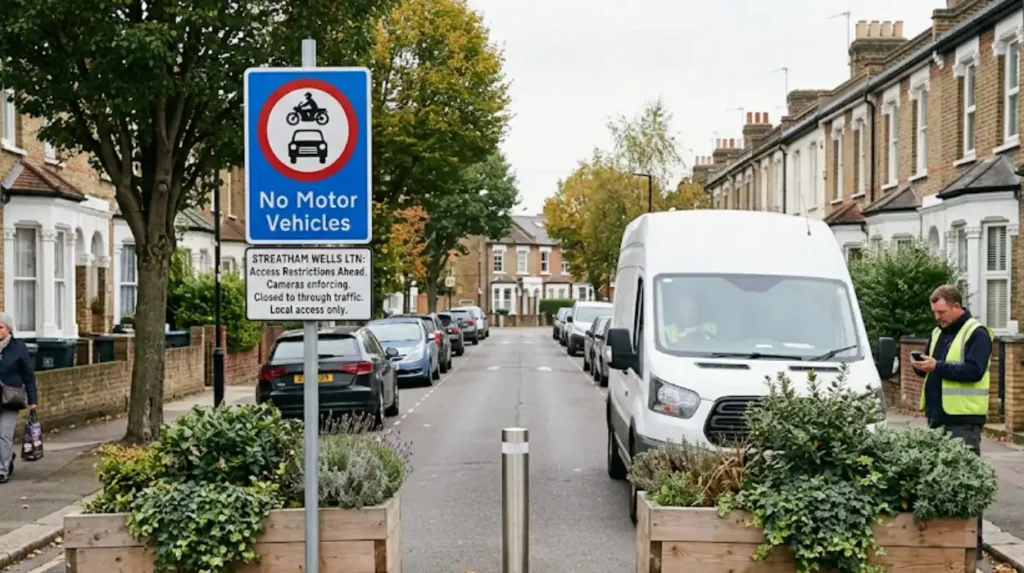
A low traffic neighbourhood, often shortened to LTN, is a street design scheme that limits motor vehicle movement inside a defined residential area. In Streatham Wells, Lambeth Council introduced experimental restrictions in 2023 and then amended them in 2024, which placed access controls on roads including Valley Road, Culverhouse Gardens, Gleneldon Road, and Leigham Avenue.
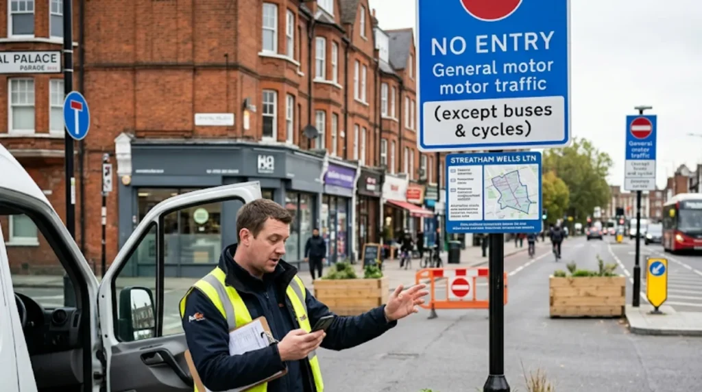
The legal basis matters because it defines enforcement. Traffic Management Orders are the statutory documents that give the council authority to enforce restrictions and parking schemes, and Lambeth says its TMO information is published through its traffic-management-orders system. In practice, that means signs, legal orders, and map-based notices determine where drivers can and cannot go.
Which roads are restricted?
The main restricted streets referenced in the Streatham Wells LTN notices are Valley Road, Culverhouse Gardens, Gleneldon Road, and Leigham Avenue, with access controls that have changed during the experimental period.
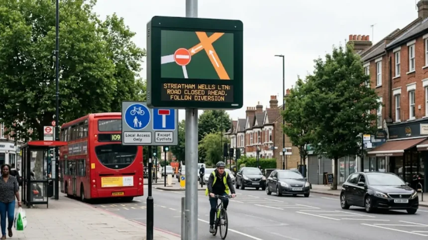
The most widely reported filter was on Valley Road, where only buses and taxis were allowed during one phase of the trial, while motorists faced fines for driving through the restriction. Later notices described an experimental suspension of prohibition of access restrictions on Culverhouse Gardens, Gleneldon Road, Leigham Avenue, and Valley Road, showing that the exact arrangement changed over time rather than remaining fixed.
This point matters for route planning. An LTN does not usually close an entire district to traffic. It blocks specific links, then pushes through-traffic onto surrounding roads such as the A23 corridor and nearby main routes.
How do the closures work?
The Streatham Wells LTN works by blocking selected motor-vehicle movements at certain points, so local access remains possible but cut-through driving is reduced.
In simple terms, the scheme separates local street access from through-routes. A driver can still enter many streets for home access, deliveries, or legitimate access needs, but cannot use the filtered roads as shortcuts across the neighbourhood. This is the central mechanism behind most LTNs in London.
The enforcement process depends on the traffic order and the signage on the road. Lambeth’s TMO pages state that traffic restrictions are backed by statutory documents, while the published notices for Streatham Wells show that experimental orders can be amended, suspended, or allowed to lapse during the trial period. For road users, the practical result is that route legality depends on the current order, not on old habits or familiar turns.
Why were the closures introduced?
The closures were introduced as part of Lambeth’s effort to trial lower traffic levels on residential streets and manage the effects of traffic displacement in Streatham Wells.
Lambeth says experimental traffic orders allow schemes to be tried for up to 18 months so residents can see how they work in practice and provide feedback. That is the key policy model behind the Streatham Wells LTN: trial the changes, monitor the impact, and then decide whether to keep, modify, or remove them.
The scheme also sits inside a wider London transport context. South London has long faced heavy boundary traffic on corridors such as the A23, and local road interventions often shift pressure from residential streets onto busier main roads. That trade-off is central to the debate around Streatham Wells and other LTNs.
What changed in 2024?
In March 2024, Lambeth suspended parts of the Streatham Wells LTN after concerns about public transport delays, and later notices showed further experimental amendments to the traffic order.
The suspension was reported after buses were said to be badly delayed on the A23 corridor, with one report stating a bus took more than two hours to travel less than three miles. Lambeth said the suspension responded to concerns about public transport delays and wider roadworks pressure in Streatham. That created a new legal and operational phase for the neighbourhood.
The later 2024 notice showed how dynamic the scheme remained. It described an experimental traffic order that omitted earlier schedules and allowed comments and objections during a fresh consultation period. For drivers, that means the Streatham Wells layout should be checked against the latest order rather than assumed from the original launch.
How do I plan a route through the area?
Plan the route as a boundary-road journey, not a neighbourhood shortcut, and use major surrounding roads instead of filtered residential streets.
The safest approach is to identify the destination first, then choose the route that keeps you on open main roads until the final turn. In Streatham, that usually means using the A23 and other connector roads, then entering the area only where access is permitted. This reduces the chance of encountering a camera, a filter, or a misleading turn into a restricted street.
For a realistic example, a driver heading across Streatham Wells should avoid relying on Valley Road as a through-route if the current order restricts motor traffic there. A resident, delivery driver, or visitor should instead approach via the nearest unrestricted road, then complete the journey through legal access points. That style of planning saves time and avoids fines.
What happens if I ignore the signs?
Ignoring the signs risks a penalty under the relevant moving-traffic or access restriction rules, because the scheme is enforced through council traffic orders and signed restrictions.
The reporting on Valley Road stated that motorists using the restricted route faced a fine of £130 once the restriction took effect. The exact penalty route depends on the active order and the enforcement system in force at the time, but the important point is that these are not advisory signs. They are legal restrictions backed by council powers.
This makes visual checks essential. Signs can change during an experimental period, and notices can create exemptions or suspensions for certain vehicles. A driver who follows an old satnav route without checking the street signs can enter a restriction unknowingly and still be liable.
How do buses, taxis, and residents fit in?
Buses and taxis have been treated differently at stages of the Streatham Wells scheme, while residents retain local access subject to the current experimental order.
One early phase allowed buses and taxis through Valley Road while restricting general motor traffic. Later amendment notices also referred to the suspension of prohibition of access restrictions on specific roads, which shows how exemptions and access rules were adjusted during the trial. That flexibility is common in experimental schemes, but it also makes current information essential.
Residents should separate two ideas: access and through-traffic. A resident normally needs access to their street, home, parking, or deliveries, but that does not automatically mean unrestricted passage through every filtered point. In short, local access does not equal all-route access.
Where can I check the latest rules?
The latest rules are published through Lambeth Council’s traffic management order pages, statutory notices, and associated consultation documents.
Lambeth says its traffic-management-orders page provides information about temporary, permanent, and experimental schemes, and that details of existing restrictions are available through its online map-based portal. The Streatham Wells notices also state that full documents and maps can be inspected through the council’s highways team and online traffic-order pages. That makes the council the primary source for current legal status.
For practical use, the best checking routine is simple: verify the street name, read the current order, and confirm the map or notice date before traveling. This is especially important in Streatham Wells because the scheme has already moved through introduction, amendment, suspension, and further consultation stages. A route app alone does not replace the legal notice.
How has the scheme affected South London?
The Streatham Wells LTN has affected South London by changing local traffic patterns, shifting some pressure onto surrounding roads, and creating a wider debate about bus reliability and neighbourhood street use.
The strongest immediate effect reported in the media was the conflict between residential traffic reduction and boundary congestion. Residents said the signs were hard to see and that nearby streets became worse, while the council and supporters argued the measures were part of a broader attempt to manage traffic inside residential streets. That pattern is typical of contested LTNs in London.
The broader implication is that road closures in Streatham Wells are not just a local design issue. They affect commuters, bus users, traders, and anyone moving through South London between the A23 and nearby residential roads. As long as the scheme remains under experimental review, route choices in the area will continue to matter.
Explore More Help & Resources
How to check if your car is ULEZ compliant for 2026
How to appeal a ULEZ fine in South London
What should drivers do today?
Drivers should check the latest Lambeth order, avoid assuming old access patterns, and use the nearest major roads for through-travel.newsfromcrystalpalace.
That rule works because the Streatham Wells LTN has changed across multiple phases, including original restrictions, amendments, suspension, and later updates. A driver who treats the area as static risks using a restricted route or missing a permitted alternative.
The most reliable everyday method is to treat the area as a filtered neighbourhood. Enter only for lawful access, observe the signs at the point of turn, and plan around the current order rather than memory. For South London journeys, that approach is faster, safer, and more likely to avoid fines.
Why does the Streatham Wells LTN still matter?
The Streatham Wells LTN still matters because it remains a live example of how London uses experimental road controls to balance residential liveability, traffic movement, and bus reliability.
The scheme shows how quickly a neighbourhood can move from consultation to implementation to revision when traffic conditions change. It also shows why up-to-date route checking matters in South London, where one road closure can redirect traffic onto several surrounding streets.
For searchers, residents, and regular drivers, the main takeaway is practical. Streatham Wells is not just a one-time closure story. It is a live traffic management case where the legal status, access rules, and route impacts have changed over time and remain relevant whenever someone travels through the area.
What is the Streatham Wells LTN?
The Streatham Wells LTN is a Low Traffic Neighbourhood introduced by Lambeth Council to reduce through-traffic on residential streets. It uses traffic filters and access restrictions under Experimental Traffic Orders while allowing local access for residents, deliveries, and emergency services where permitted.