Key Points
- The TCS London Marathon 2026 will take place on Sunday, 26 April, following its usual route through central and east London.
- The route passes through Greenwich, Lewisham, Southwark, Tower Hamlets, the City of London, and Westminster, meaning wide‑ranging road closures and transport changes in these boroughs.
- In Central London, major roads around Trafalgar Square, Whitehall, Pall Mall East, Cockspur Street, parts of the Strand, Charing Cross Road, and Duncannon Street will close from 7.30 am until 10 pm on race day.
- Spring Gardens, used for event infrastructure, will be shut from 6 am on Friday, 24 April, and will only reopen at 6 am on Monday, 27 April.
- Roads around the finish line in Westminster, including The Mall, Constitution Hill and Birdcage Walk, will also be closed for much of Sunday.
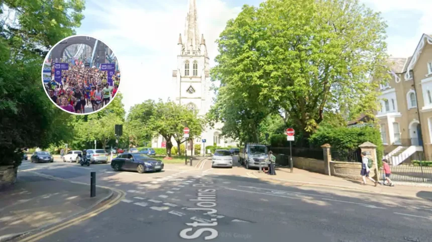
- Start‑area closures in Blackheath and Greenwich will begin from around 4 am until mid‑afternoon, affecting roads such as Shooters Hill Road, Charlton Way, St John’s Park, Old Dover Road, and Vanbrugh Park.
- The marathon route follows the Thames through the Docklands, resulting in daytime closures across Canary Wharf, the Isle of Dogs, Rotherhithe, Wapping, Westcombe Park, Deptford, Bermondsey, and Shadwell.
- In Canary Wharf, key streets such as East Ferry Road, Marsh Wall, Bank Street, Upper Bank Street, Montgomery Street and Charter Street will be closed from about 8 am until 8.30 pm.
- Organisers have issued area‑by‑area PDF resident information packs instead of a single public text list, covering Canary Wharf, Greenwich, Isle of Dogs, Queen Anne’s Gate, Rotherhithe, Trafalgar Square, Wapping and Westcombe Park.
- Motorists are advised to check the official road‑closures page and local information packs for precise closure times, parking suspensions, and access conditions.
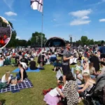
- The marathon is expected to bring crowds of more than 50,000 participants and tens of thousands of spectators, with local authorities urging residents to plan ahead to avoid disruption.
Greenwich (South London News) April 20, 2026, what is changing on London’s roads for marathon day? Greenwich – TCS London Marathon organisers have set out detailed road‑closure plans for the 2026 race, warning drivers and residents across central and east London to prepare for widespread disruption on Sunday, 26 April. The event, which will again draw more than 50,000 runners and large crowds of spectators, will follow the traditional loop from Greenwich through Blackheath, the Docklands and central London, finishing on The Mall. Organisers say closures are designed to keep participants and spectators safe while minimising the impact on local services, but the reality is that many roads and side streets will be shut for much of the day.
- How will the start area in Blackheath and Greenwich be affected?
- What do the closures look like in Canary Wharf and the Docklands?
- What will happen around Trafalgar Square and central Westminster?
- How will the finish area and birdcage walk be managed?
- Where can residents and drivers find the full street‑by‑street details?
- What is the wider impact on London’s transport and economy?
- Background to the 2026 marathon road‑closure arrangements
- Predictions for how these closures will affect Londoners and visitors
How will the start area in Blackheath and Greenwich be affected?
In the south‑east London start area, the London‑based event organisers’ resident information packs state that roads around Blackheath and Greenwich will close from the early hours of Sunday morning, typically from about 4 am until mid‑ to late afternoon.
As reported by the London Marathon Events team, routes such as Shooters Hill Road, Charlton Way, St John’s Park, Old Dover Road and Vanbrugh Park are all expected to be closed for several hours to allow runners to assemble and then pass through the zone. Local authorities have also confirmed that yellow advanced‑warning signs are already visible on affected streets, and that parking suspensions and “no waiting / no loading” restrictions will apply on and near the route from the early hours of marathon day.
What do the closures look like in Canary Wharf and the Docklands?
Moving along the Thames, the marathon route loops through Canary Wharf and the Isle of Dogs, where organisers have published a specific Canary Wharf resident leaflet detailing closures. As reported by the same document, the London Marathon Events team wrote that the race will use several different roads in the Canary Wharf area, including Montgomery Street, Water Street, Charter Street, East Ferry Road, Marsh Wall, Bank Street and Upper Bank Street, among others.
These streets are scheduled to be closed from 8 am until 20.30 on Sunday, 26 April, with an additional extended closure between 6 am and 8 am in a small section of Canary Wharf to allow for infrastructure set‑up.
West Ham–based transport commentator Rose Smith, writing for Premium Transfers, noted that by 8 am Tower Bridge will be sealed and the wider Docklands corridor will effectively become a one‑way flow for runners and official traffic only.
That means drivers travelling between East London and the City may face significant delays or need to use alternative routes via the northern or southern bypass corridors.
What will happen around Trafalgar Square and central Westminster?
In central London, the road‑closure map becomes even more extensive, according to the official London Marathon Events portal. The organisers state that roads around Trafalgar Square will be closed from 7.30 am until 10 pm on Sunday, reflecting the heavy concentration of spectators, broadcast crews and finish‑area operations in the area.
As London‑Now has reported, affected streets include Whitehall, Pall Mall East, Cockspur Street, and parts of the Strand, Charing Cross Road and Duncannon Street, all of which will be largely inaccessible to general traffic during those hours.
Spring Gardens, which is used for event infrastructure such as timing booths and broadcast points, will be shut from 6 am on Friday, 24 April, and will not reopen until 6 am on Monday, 27 April, according to the organisers’ guidance. Residents and businesses in the Westminster zone are advised to consult the “Queen Anne’s Gate” and “Trafalgar Square” resident information packs, which list precise closure times and loading/access arrangements for each street.
How will the finish area and birdcage walk be managed?
Around the finish line in Westminster, the marathon route funnels runners along The Mall towards the finish arch near Buckingham Palace. As outlined in the central‑London closure guidance, roads such as The Mall, Constitution Hill and Birdcage Walk, plus surrounding side streets, will be closed for much of Sunday while the field is processed and spectators line the route.
The Metropolitan Police and event stewards are expected to manage pedestrian flows and vehicle access, with temporary pedestrian‑only zones and controlled crossing points in place for residents and emergency services.
Where can residents and drivers find the full street‑by‑street details?
Unlike some city‑wide events, the London Marathon organisers have not published one single public web page listing every affected road and its exact closure window in plain‑text form. Instead, as reported by the London Marathon Events website, the organisation has released downloadable PDF resident information packs and maps for specific areas, including Canary Wharf, Greenwich, the Isle of Dogs, Queen Anne’s Gate, Rotherhithe, Trafalgar Square, Wapping and Westcombe Park.
Users are directed to pick their area on the official road‑closures page and then check the relevant PDF, which shows every affected road, the type of parking restriction and the precise reopening time.
Motorists and residents are being urged by the organisers to plan ahead, allow extra travel time and consider using public transport, cycling or walking where possible on Sunday. TfL has indicated that bus routes across the affected areas will be diverted or suspended, and some Tube stations in Greenwich and Blackheath may impose temporary access restrictions at peak times.
What is the wider impact on London’s transport and economy?
Commenting on the broader effect, a London‑based travel‑and‑events guide for the 2026 marathon notes that the race will effectively shut down a wide corridor from Greenwich through to Westminster for several hours, with major thoroughfares like the approaches to Tower Bridge and Victoria Embankment also sealed off during the peak of the race.
The same source adds that while the closures will cause disruption for drivers and some local businesses, the event is traditionally expected to bring a boost to nearby hospitality, retail and tourism sectors through increased footfall and media exposure.
Background to the 2026 marathon road‑closure arrangements
The TCS London Marathon has been held annually since 1981 and has long required complex road‑closure and traffic‑management plans as it passes through some of the busiest parts of the capital. Over the years, organisers have moved away from simple text lists of closures and instead opted for area‑by‑area PDF maps and leaflets, which allow more detailed depictions of each road, parking bay and access point than a single web page could easily show.
Local authorities and Transport for London have worked closely with London Marathon Events to coordinate policing, traffic‑light changes, bus diversions and temporary pedestrian zones, with the aim of keeping the route safe while minimising long‑term disruption to residents.
The use of yellow advanced‑warning signs and early communication via resident packs has become standard practice, giving drivers and businesses weeks to adjust their travel and delivery plans ahead of race day.
Predictions for how these closures will affect Londoners and visitors
For local residents in Greenwich, Lewisham, Southwark, Tower Hamlets, the City of London and Westminster, the 2026 marathon road‑closure plan means planning Sunday journeys in advance, especially if they live close to the route or rely on through‑traffic roads. Those who work in Canary Wharf, the City or Westminster may need to leave for work earlier than usual or consider alternative modes of transport, such as cycling or walking where safe, to avoid the most congested corridors.