Lambeth’s skyline is defined by an unusually broad architectural mix. Medieval ecclesiastical buildings, Edwardian civic architecture, Festival of Britain modernism, Brutalist cultural buildings and contemporary riverside landmarks all occupy the same urban landscape.
- What makes Lambeth’s skyline architecturally distinctive?
- How does the London Eye shape Lambeth’s skyline?
- Why is Royal Festival Hall important to Lambeth’s architectural identity?
- How does the National Theatre contribute to Lambeth’s skyline?
- What architectural role does County Hall play in Lambeth?
- Why is Lambeth Palace significant to the skyline?
- How does the MI6 building at Vauxhall Cross define Lambeth’s modern skyline?
- What makes Lambeth Town Hall an important Brixton landmark?
- How does the Oxo Tower contribute to Lambeth’s riverside architecture?
- Which architectural landmarks are most important for understanding Lambeth’s history?
- How can visitors experience Lambeth’s architectural landmarks?
- How will Lambeth’s skyline remain important as London develops?
The borough stretches along a major section of the River Thames and includes South Bank, Waterloo, Lambeth, Vauxhall, Kennington, Brixton, Clapham and Streatham. This geographical range gives Lambeth several distinct architectural identities rather than one uniform skyline.
The most recognisable landmarks include the London Eye, Royal Festival Hall, National Theatre, County Hall, Lambeth Palace, the MI6 building at Vauxhall Cross, Lambeth Town Hall and the Oxo Tower. Each represents a different period of London’s architectural development.
Lambeth Council formally recognises the importance of views and landmark silhouettes in its planning framework. Its local views documents specifically identify landmarks such as the London Eye and St Paul’s Cathedral and protect important panoramic relationships across the Thames and South Bank.
Architectural significance also extends beyond height. Lambeth’s statutory heritage framework recognises architectural interest, historic interest, historical associations, group value, age and rarity when assessing listed buildings. Grade I represents exceptional interest, Grade II* identifies particularly important buildings, and Grade II covers buildings of special interest.
For visitors, this means Lambeth is best understood as a layered architectural landscape. The skyline changes from the monumental stone façade of County Hall to the exposed concrete terraces of the National Theatre and the engineered circular structure of the London Eye.
What makes Lambeth’s skyline architecturally distinctive?
Lambeth’s skyline is distinctive because historic, civic, cultural and contemporary buildings stand close together beside the River Thames, creating contrasting silhouettes. County Hall, the London Eye, Royal Festival Hall, National Theatre, Lambeth Palace and Vauxhall landmarks represent different architectural periods.
The South Bank provides the clearest concentration of major architectural landmarks. Lambeth Council describes the South Bank Conservation Area as a nationally important collection of twentieth-century buildings facing the Thames. County Hall is the earliest major building in the group, while the Royal Festival Hall became the catalyst for post-war development.
The architectural sequence is particularly clear when travelling along the river. County Hall introduces early twentieth-century Edwardian Baroque architecture. Royal Festival Hall introduces post-war modernism. The National Theatre presents late twentieth-century Brutalism. The London Eye adds a large-scale engineering structure rather than a conventional building.
Further south, the architectural character changes again. Vauxhall contains the post-modern MI6 headquarters and newer high-rise residential development. Brixton has its own civic skyline around Lambeth Town Hall, St Matthew’s Church and the Ritzy Cinema.
This variety gives Lambeth several recognisable visual zones. South Bank is dominated by cultural and riverside landmarks. Lambeth and Kennington retain stronger historic and ecclesiastical references. Brixton has a civic and commercial town-centre skyline. Vauxhall combines infrastructure, offices and residential towers.
The result is a skyline shaped by function as much as architectural style. Government, religion, entertainment, culture, transport, tourism and residential development have all contributed visible landmarks.
How does the London Eye shape Lambeth’s skyline?
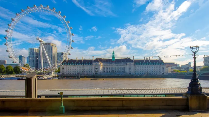
The London Eye is Lambeth’s most recognisable contemporary skyline landmark, rising 135 metres beside the Thames. Its circular steel structure, enclosed observation pods and riverside position create a distinctive silhouette visible across central London and from numerous Lambeth viewpoints.
The London Eye opened at the turn of the millennium and transformed the visual relationship between the South Bank and Westminster. Its 135-metre height makes it substantially taller than most surrounding South Bank buildings. Official London Eye information records 32 passenger pods, a 424-metre circumference and a total structure weight of approximately 2,100 tonnes.
Its engineering is central to its architectural identity. The wheel is supported from one side by a large A-frame rather than by a conventional pair of towers. The structure uses a central hub and spindle connected to the outer and inner rims through cable spokes.
This construction gives the London Eye an unusually open silhouette. Traditional towers depend on solid vertical mass. The London Eye instead creates a large circular void against the sky.
Its location also strengthens its visual importance. The wheel stands beside the River Thames, where there is relatively open space around the structure. This allows the entire circular form to remain visible from Westminster, the Thames Path and numerous South Bank viewpoints.
Lambeth Council’s local views work specifically considers panoramic views involving the London Eye and other major London landmarks. The council also uses views from the London Eye to understand the relationship between Waterloo, north Lambeth and the wider city.
The London Eye therefore functions as both architecture and infrastructure. It is a visitor attraction, observation structure, engineering project and visual marker within Lambeth’s skyline.
Why is Royal Festival Hall important to Lambeth’s architectural identity?
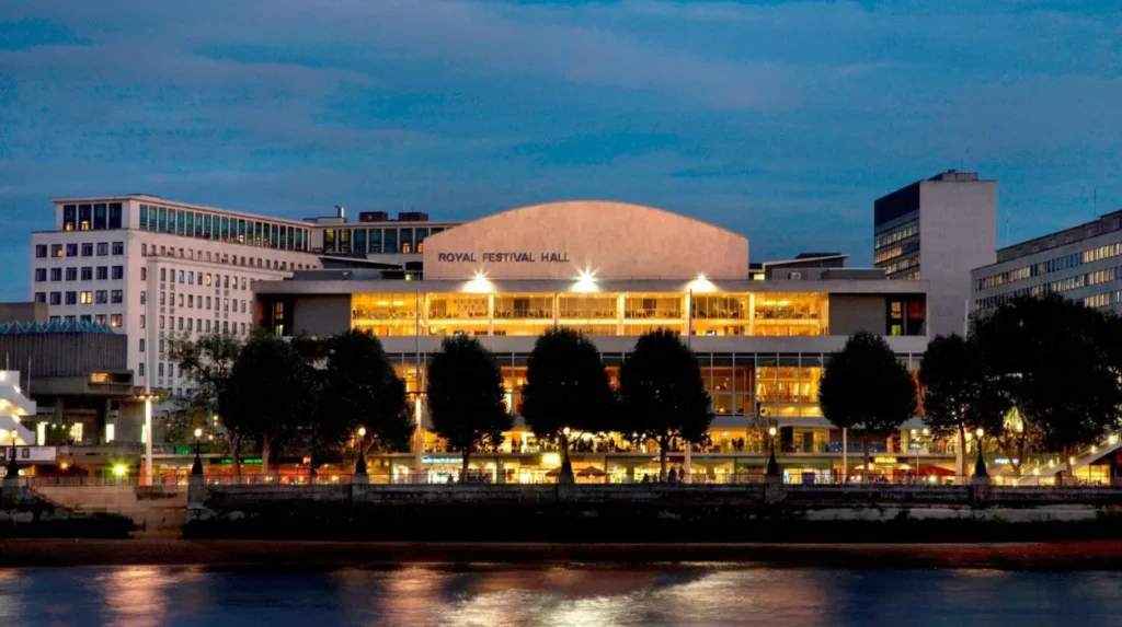
Royal Festival Hall is a Grade I listed cultural landmark created for the 1951 Festival of Britain. Its spacious modernist design, riverside setting and large auditorium established the South Bank as a major cultural district and influenced the architectural character of Lambeth.
Royal Festival Hall forms the historic centre of the Southbank Centre. The venue opened as part of the 1951 Festival of Britain and has a 2,700-capacity auditorium. The building received Grade I listed status, reflecting its exceptional architectural and historical importance.
The building represents a major shift away from the monumental classical architecture associated with earlier civic buildings. Its design prioritises light, openness, circulation and modern materials.
Its architectural importance extends beyond the auditorium itself. The building includes foyers and public spaces that connect the cultural programme with the surrounding riverside environment. The Southbank Centre identifies Royal Festival Hall as its oldest and largest building.
The building also helped establish the wider South Bank architectural ensemble. Lambeth Council states that Royal Festival Hall was the centrepiece of the Festival of Britain site and acted as a catalyst for the development of the South Bank.
That influence remains visible today. The surrounding cultural buildings create a continuous architectural environment along the Thames. Visitors encounter Royal Festival Hall alongside the Hayward Gallery, Queen Elizabeth Hall, Purcell Room and National Theatre.
The building is particularly important for understanding Lambeth’s twentieth-century architectural history because it represents the transition from pre-war civic monumentalism to post-war modernist public architecture.
Its Grade I status also demonstrates that modern architecture forms an important part of Lambeth’s protected heritage. Architectural significance is not limited to medieval or Victorian buildings.
How does the National Theatre contribute to Lambeth’s skyline?
The National Theatre is one of Lambeth’s defining Brutalist landmarks. Designed by Sir Denys Lasdun and built between 1969 and 1976, its exposed concrete terraces, multiple levels and dramatic geometry create a strong riverside silhouette and landmark cultural presence.
The Royal National Theatre occupies a prominent position on Upper Ground beside the Thames. Historic England lists the building at Grade II*, recognising its architectural and historical significance. The official listing identifies Sir Denys Lasdun as its architect and dates the theatre complex to 1969–76.
The building uses reinforced concrete, flat roofs and an interconnected arrangement of large volumes. Its Lyttelton and Olivier auditoria are arranged differently within the overall composition, producing the stepped and layered exterior associated with Lasdun’s design.
The architecture reflects the functional requirements of a major theatre. Public foyers, performance spaces, circulation routes, technical areas and external terraces are integrated into the overall structure.
This makes the National Theatre different from conventional monumental buildings. Its external form communicates the complexity of the institution inside.
The building’s exposed concrete surfaces also create a powerful material contrast with the stone façades of County Hall. This contrast is one reason the South Bank has such a distinctive architectural character.
The National Theatre remains an important reference point for architectural studies of post-war Britain. Its listing recognises not simply its age but its architectural design, planning and contribution to the cultural landscape.
For visitors exploring Lambeth, the building is also a practical landmark. Its position on the South Bank places it within walking distance of Royal Festival Hall, the London Eye, County Hall and the Thames riverside.
Its terraces and large horizontal forms are particularly prominent from across the Thames. The building therefore contributes to Lambeth’s skyline through mass and texture rather than exceptional height.
What architectural role does County Hall play in Lambeth?
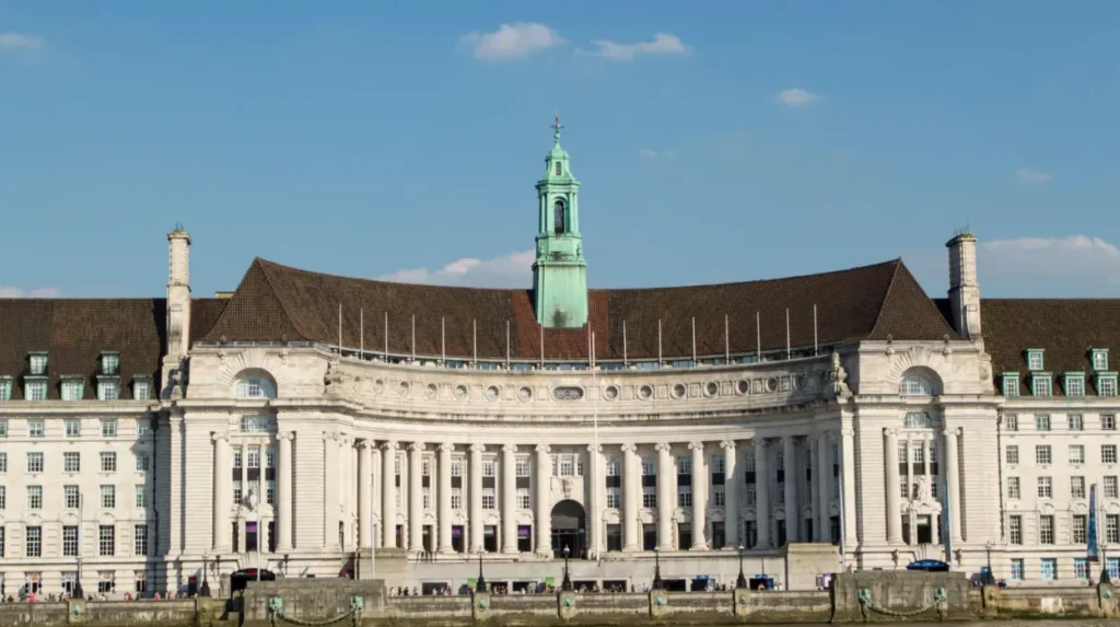
County Hall provides Lambeth’s major Edwardian civic landmark. Designed by Ralph Knott between 1911 and 1933, its Portland stone elevations, Ionic columns, mansard roof and long curved river frontage create a monumental architectural presence beside Westminster.
County Hall stands on Belvedere Road overlooking the Thames. Historic England lists its main block at Grade II*. The building was designed by Ralph Knott and constructed in stages between 1911 and 1933.
Its architecture is fundamentally different from the modernist buildings that surround it. The principal river elevation uses Portland stone ashlar and contains five storeys beneath a steep mansard roof. The central façade forms a pronounced concave curve containing 19 bays.
The building’s giant Ionic order gives it a formal civic appearance. Sculptural figures, carved details and carefully composed façades reinforce its original administrative purpose.
County Hall was built to house London’s county administration. The main building opened in 1922, while the wider complex was completed in 1933. It subsequently served London’s local government until the abolition of the Greater London Council in 1986.
Its location opposite the Palace of Westminster is architecturally significant. The building forms part of a major Thames-side civic composition in which governmental architecture occupies both sides of the river.
The scale of County Hall also helps explain why the South Bank skyline developed as a layered sequence rather than a collection of isolated towers.
The building’s long horizontal form contrasts strongly with the vertical emphasis of Westminster’s towers and the circular geometry of the London Eye.
Today, County Hall continues to function as a major landmark and contains hotels, attractions and other commercial uses. Its protected status ensures that its architectural character remains an important part of Lambeth’s riverside identity.
As you explore the modern South Bank, you are crossing land with a deep heritage. Read about the full [Insert Anchor Text for History Article Here] to understand its origins.
Why is Lambeth Palace significant to the skyline?
Lambeth Palace provides a medieval and Tudor architectural counterpoint to Lambeth’s modern riverside landmarks. The Archbishop of Canterbury’s historic London residence contains surviving medieval structures, including the Guard Room, Lollard’s Tower and Morton’s Tower.
Lambeth Palace is one of the borough’s most historically important architectural complexes. Lambeth Council identifies it as the heart of the Lambeth Palace Conservation Area, which was first designated in 1968. The conservation area also includes former St Mary’s Church and historic development along Lambeth Road.
The site entered the possession of the Archbishop of Canterbury in 1197. Records from 1270 describe buildings collectively known as the Archbishop’s Houses. The site was attacked and burned during the Peasants’ Revolt in 1381, leading to reconstruction.
One of its most recognisable structures is Lollard’s Tower. The lower part was built by Archbishop Henry Chichele in 1434–35. The tower reflects the medieval development of the Palace and remains an important historical component of the site.
Morton’s Tower provides another major architectural feature. Constructed in 1486, it incorporates parts of an earlier great gate and represents an important example of early Tudor brick architecture.
The Palace differs from the South Bank landmarks because its significance comes from accumulated historical fabric rather than a single modern architectural concept.
Its buildings also demonstrate how Lambeth’s skyline contains layers from very different periods. Medieval brickwork and historic towers coexist within sight of the London Eye and modern riverside development.
For architectural visitors, Lambeth Palace is therefore essential for understanding the borough’s long chronology. The site demonstrates that Lambeth’s identity predates the modern London skyline by many centuries.
How does the MI6 building at Vauxhall Cross define Lambeth’s modern skyline?
The MI6 headquarters at Vauxhall Cross is a major post-modern riverside landmark designed by Terry Farrell. Its stepped massing, concrete construction and green-tinted glazing create a distinctive silhouette beside Vauxhall Bridge and the Albert Embankment.
The MI6 building is formally the headquarters of the Secret Intelligence Service. It stands at Vauxhall Cross on the Thames and is one of Lambeth’s most recognisable late twentieth-century landmarks.
Lambeth Council’s landmark-view documentation identifies Terry Farrell’s building as an iconic post-modern landmark. The council describes its stepped façade as being formed from concrete and green glass and identifies the relationship between the building and the river as an important visual characteristic.
The building’s stepped form is particularly important. Rather than rising as a simple rectangular tower, the structure consists of interconnected volumes with terraces and vertical elements.
Its architecture responds directly to its riverside location. The building is positioned beside Vauxhall Bridge, where its unusual massing is visible from Westminster and Millbank as well as from the Lambeth riverfront.
Lambeth’s planning framework specifically protects important views towards the MI6 building. The council identifies a public riverside viewing location at Millbank and states that new development should not compromise the landmark’s silhouette or dominate its setting.
The building also illustrates the changing scale of Vauxhall. Lambeth’s planning documents identify the MI6 building and St George Wharf as established Vauxhall landmarks within an area containing transport infrastructure, commercial buildings and residential development.
This makes Vauxhall an important part of Lambeth’s contemporary architectural story. The area demonstrates how twentieth- and twenty-first-century development has introduced taller, denser and more varied forms into the borough’s skyline.
What makes Lambeth Town Hall an important Brixton landmark?
Lambeth Town Hall is a Grade II listed Edwardian civic building completed in 1908. Designed by Septimus Warwick and H Austen Hall, its red brick, Portland stone detailing and prominent clock tower form the architectural centrepiece of Brixton’s civic landscape.
Lambeth Town Hall stands at the junction of Brixton Hill and Acre Lane. Historic England lists the building at Grade II and records its construction between 1905 and 1908, followed by major extensions between 1935 and 1938.
The building uses red brick with Portland stone dressings and follows a modified Baroque architectural style. Its L-shaped plan occupies a prominent triangular position, giving the building strong visibility from surrounding streets.
The clock tower is its defining skyline feature. The tower rises above the main building and contains clock faces beneath open pediments. Sculpted figures representing Justice, Science, Art and Literature occupy the tower’s upper composition.
The building also has significant civic interiors. Historic England records the council chamber, assembly hall, committee rooms, original fittings and decorative features.
Lambeth Town Hall is especially important because it demonstrates that the borough’s architectural identity is not confined to the Thames. Brixton has a distinct civic townscape centred on the Town Hall, St Matthew’s Church, Tate Library and the Ritzy Cinema.
Lambeth Council planning material identifies the Town Hall and nearby St Matthew’s Church as memorable Brixton landmarks.
The building also contributes to the area’s nighttime identity. Recent planning documentation discusses architectural lighting designed to reveal the listed building and strengthen its presence within Brixton.
For visitors, Lambeth Town Hall provides an accessible architectural counterpoint to the monumental buildings of South Bank. Its clock tower, civic composition and Edwardian detailing show how local government architecture shaped the visual identity of inner London neighbourhoods.
How does the Oxo Tower contribute to Lambeth’s riverside architecture?
The Oxo Tower is a 1930s riverside landmark on the South Bank, recognised by its distinctive rooftop lettering and industrial heritage. Its conversion into Oxo Tower Wharf created a mixed-use architectural destination combining homes, design studios, shops, restaurants and exhibition space.
Oxo Tower Wharf occupies a prominent position along the Thames between Waterloo and Blackfriars Bridge. The landmark has been associated with the South Bank skyline since the 1930s.
The site’s history began earlier. A power station was constructed there around 1900 to supply electricity to the Post Office. During the late 1920s, the Liebig Extract of Meat Company acquired the site and redeveloped the riverside frontage.
The famous tower became associated with the Oxo brand through its architectural lettering. This created one of London’s most recognisable examples of commercial identity integrated into a building’s silhouette.
The present Oxo Tower Wharf development demonstrates another important architectural process: adaptive reuse. Industrial and commercial buildings are retained and given new functions rather than being completely replaced.
Today, the development contains co-operative housing, design studios, retail spaces, restaurants, cafés, shops and the Oxo Gallery.
Its architectural importance therefore extends beyond the tower itself. The building forms part of the wider industrial and cultural transformation of the South Bank.
The Oxo Tower also adds a different scale to Lambeth’s skyline. Unlike the London Eye, it does not depend on exceptional height. Unlike County Hall, it does not rely on monumental civic architecture. Its recognisable form comes from its tower, riverside position and distinctive historic identity.
For visitors exploring the Thames, Oxo Tower Wharf provides a useful example of how Lambeth’s architecture has evolved through industrial redevelopment, cultural activity and residential reuse.
Which architectural landmarks are most important for understanding Lambeth’s history?
The strongest architectural sequence runs from Lambeth Palace and County Hall through Royal Festival Hall and the National Theatre to the London Eye, Oxo Tower and Vauxhall landmarks. Together, they represent medieval, Tudor, Edwardian, post-war, Brutalist and contemporary architectural development.
Lambeth’s architectural history is best understood chronologically as well as geographically.
Lambeth Palace represents the medieval and Tudor periods. Its surviving structures demonstrate the long association between the site and the Archbishop of Canterbury.
County Hall represents early twentieth-century civic ambition. Its construction between 1911 and 1933 produced one of London’s most substantial Edwardian Baroque public buildings.
Royal Festival Hall represents the post-war transformation of the South Bank. Created for the 1951 Festival of Britain, it established modern cultural architecture as a defining part of the riverside.
The National Theatre represents another stage of modern architecture. Its 1969–76 construction and Grade II* status demonstrate the historical importance now attached to major post-war buildings.
The Oxo Tower represents industrial and commercial heritage adapted for contemporary mixed use. Its history links electricity generation, food manufacturing, advertising and modern cultural development.
The London Eye represents large-scale contemporary engineering. Its 135-metre circular structure introduced a new visual landmark to the South Bank at the beginning of the twenty-first century.
The MI6 building represents late twentieth-century post-modernism and the changing architectural character of Vauxhall. Its stepped green-glass and concrete form remains a protected component of important riverside views.
Lambeth Town Hall represents Edwardian civic architecture outside the riverside core. Its prominent tower remains central to Brixton’s townscape.
These buildings collectively demonstrate why Lambeth’s skyline cannot be defined by one architectural style. Its identity comes from chronological layering.
Explore More Area Guide
How Accessible Is Lambeth for International Visitors? London 2026
Best Riverside Attractions in Lambeth | South London 2026
How can visitors experience Lambeth’s architectural landmarks?
Visitors can experience Lambeth’s architecture most effectively by combining the Thames riverside with neighbourhood walks through Lambeth, Vauxhall and Brixton. South Bank provides the densest concentration, while Lambeth Palace, Lambeth Town Hall and Vauxhall reveal different architectural periods.
The South Bank provides the simplest starting point because several major landmarks are concentrated within a relatively compact area. Royal Festival Hall, County Hall, the National Theatre, Oxo Tower Wharf and the London Eye can all be incorporated into a riverside architectural walk.
Belvedere Road is particularly useful for orientation. Lambeth Council’s film-location information identifies the road as a location associated with the London Eye, Southbank Centre and National Theatre.
The Thames also provides important long-distance viewpoints. Looking across the river reveals the relationship between County Hall, the London Eye, Royal Festival Hall and the National Theatre.
Vauxhall provides a different experience. The MI6 building is best understood from the river because its stepped composition and relationship with Vauxhall Bridge are visible at a distance. Lambeth Council specifically identifies a public riverside viewing location across the Thames.
Brixton provides another architectural route. Lambeth Town Hall forms part of a civic group around Windrush Square, alongside St Matthew’s Church, Tate Library and the Ritzy Cinema. Planning documents identify these buildings as part of a coherent historic townscape.
For digital nomads and business travellers, the South Bank also provides practical access to cultural venues, cafés, public spaces and transport connections. Southbank Centre states that Waterloo is its nearest railway station and that more than 20 London bus routes pass within 500 metres of its venues.
Architectural exploration therefore works particularly well as part of a wider Lambeth visit. The borough’s landmarks are connected by the Thames, public transport, pedestrian routes and historic neighbourhoods.
How will Lambeth’s skyline remain important as London develops?
Lambeth’s architectural landmarks will remain important because planning policy protects significant views, listed buildings and conservation areas while allowing the borough to accommodate new development. The skyline will continue evolving around established heritage assets and important riverside viewpoints.
Lambeth’s planning framework treats architectural landmarks as part of the wider townscape rather than isolated buildings. The council’s local views documents identify landmark silhouettes and panoramic viewpoints that influence how new development is assessed.
The South Bank Conservation Area provides an important example. Lambeth Council identifies it as a nationally important collection of twentieth-century buildings, with County Hall and Royal Festival Hall forming major historical components.
Listed-building protection provides another layer of control. Lambeth’s statutory framework recognises architectural interest, historic interest, historical associations, group value, age and rarity when buildings are assessed for listing.
This framework does not freeze the skyline. Lambeth contains areas of significant regeneration and changing building heights, particularly around Vauxhall and the wider riverside corridor.
The architectural challenge is therefore one of integration. New buildings need to coexist with landmarks whose silhouettes already have cultural, historic and planning significance.
This is particularly relevant around the Thames. Open river views provide long-distance perspectives towards major landmarks. A new tall structure can affect a landmark’s visibility from several kilometres away.
Lambeth Council’s landmark-view guidance for the MI6 building explicitly states that development should not compromise the building’s silhouette or dominate its setting.
The same principle applies more broadly to the borough’s architectural identity. The future skyline will contain new buildings, but its strongest visual references remain the historic and cultural landmarks that already define Lambeth.
Lambeth’s skyline is therefore not simply a collection of tall structures. It is a visual record of changing political institutions, cultural priorities, engineering capabilities, industrial activity and urban planning.
From the medieval towers of Lambeth Palace to the circular London Eye, the borough contains architectural evidence from more than eight centuries. County Hall represents civic government, Royal Festival Hall represents post-war cultural renewal, the National Theatre represents Brutalist public architecture, the Oxo Tower represents industrial adaptation, and the MI6 building represents late twentieth-century post-modernism.
Together, these landmarks define Lambeth’s architectural character and explain why the borough remains one of the most visually varied parts of central and inner London.
What are the most famous architectural landmarks in Lambeth?
Lambeth’s most recognisable architectural landmarks include the London Eye, Royal Festival Hall, National Theatre, County Hall, Lambeth Palace, MI6 headquarters at Vauxhall Cross, Lambeth Town Hall and the Oxo Tower.