Lambeth’s waterways reveal an important part of South London’s geography, history and urban development. The borough has a long relationship with the River Thames, which forms its northern boundary and connects historic riverside neighbourhoods with modern cultural attractions, residential developments and public spaces. Although Lambeth does not have an extensive network of operational canals, visitors can explore riverside promenades, historic river crossings, landscaped waterfronts and locations associated with London’s lost rivers.
- Which Waterways Can Visitors Explore in Lambeth?
- Where Can Visitors Walk Along the River Thames in Lambeth?
- What Can Visitors Discover at Albert Embankment?
- Where Are Effra Quay and the Isle of Effra?
- What Is the River Effra and Where Did It Flow Through Lambeth?
- How Did the River Effra Influence Brixton and Kennington?
- Can Visitors Still See Evidence of the River Effra?
- Which Riverside Gardens and Green Spaces Can Visitors Explore?
- How Does the Thames Path Connect Lambeth With Other South London Attractions?
- Can Visitors Explore the South Bank and Queen’s Walk From Lambeth?
- How Did Lambeth’s Waterways Influence the Borough’s Historical Development?
- Are There Any Former Canals Near Lambeth?
- What Is the Best Time to Explore Lambeth’s Waterways?
- How Can Visitors Reach Lambeth’s Waterways Using Public Transport?
- Why Are Lambeth’s Waterways Important for Future Urban Development?
- What Should Visitors Include in a Lambeth Waterways Walking Itinerary?
- Suggested Lambeth riverside walking route
- Where Can Visitors Explore Lambeth’s Canals and Waterways?
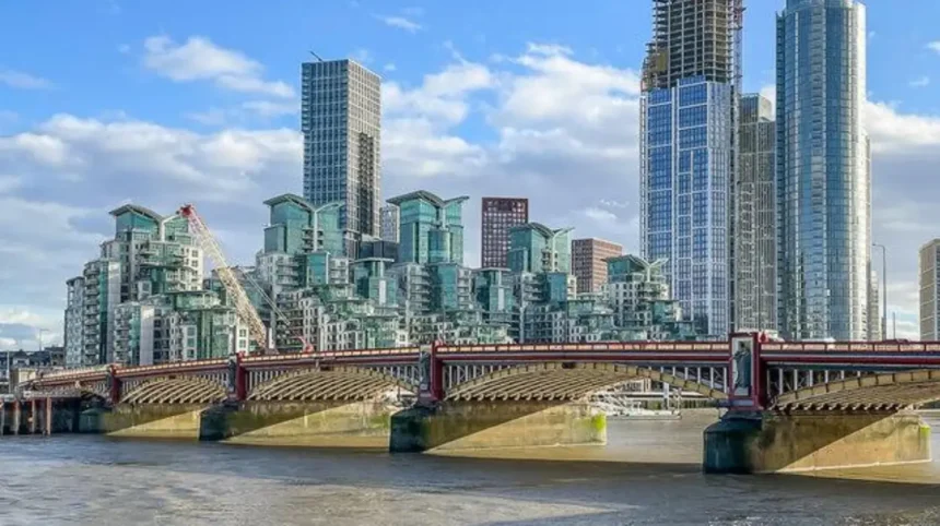
The River Thames is the main waterway for visitors exploring Lambeth. Its southern riverbank includes Albert Embankment, Lambeth Bridge, Vauxhall Bridge and several recently improved public spaces. These locations provide opportunities for walking, photography, sightseeing and understanding how river transport influenced London’s expansion.
Lambeth also has a fascinating connection with the River Effra, a historic watercourse that once flowed through Brixton, Herne Hill and Vauxhall before becoming incorporated into London’s underground sewer network. Its former route demonstrates how urban development transformed the natural landscape of South London.
For tourists and leisure travellers, exploring Lambeth’s waterways provides access to historic architecture, riverside gardens, cultural landmarks and pedestrian routes. Residents and business travellers also benefit from these accessible outdoor spaces, which connect established neighbourhoods with modern developments.
Understanding the distinction between open rivers, former canals and buried waterways helps visitors explore Lambeth accurately. The borough’s waterway heritage is not limited to what remains visible above ground. Its historic river systems also explain the development of streets, neighbourhoods and infrastructure.
Which Waterways Can Visitors Explore in Lambeth?
Visitors can explore the River Thames directly, alongside riverside public spaces and historic locations associated with the River Effra. Lambeth also contains a small section of the River Graveney. These waterways represent the borough’s natural geography, transport history and changing urban landscape.
Lambeth’s waterways fall into different geographical and historical categories. The River Thames is the most prominent open waterway and provides the borough’s most accessible riverside experience. It connects Lambeth with central London and neighbouring South London districts.
The River Effra represents a different aspect of the borough’s waterway heritage. Historically, this natural river flowed from the higher ground of South London towards the Thames at Vauxhall. Its channel was gradually covered during the nineteenth century and incorporated into London’s sewer infrastructure.
The River Graveney is another watercourse associated with Lambeth’s southwestern geography. Lambeth Council identifies the Thames and a small section of the Graveney as the borough’s open rivers. Lambeth Council+1
These waterways serve different purposes in understanding Lambeth.
- River Thames: An open tidal river supporting navigation, riverside recreation and major transport connections.
- River Effra: A historic natural river whose buried course explains parts of Lambeth’s urban geography.
- River Graveney: A smaller watercourse associated with the borough’s southwestern boundary.
- Former canal connections: The wider South London canal network provides additional historical context, although the former Grand Surrey Canal was not an operational canal within Lambeth.
The distinction matters because visitors searching for canals in Lambeth will find a stronger network of riverside walking opportunities than traditional canal towpaths.
Where Can Visitors Walk Along the River Thames in Lambeth?
Visitors can walk along the Thames at Albert Embankment, around Lambeth Bridge and towards Vauxhall Bridge. These riverside routes provide views of Westminster, historic buildings, modern architecture and public spaces connected to the wider Thames Path walking network.
The River Thames is the central attraction for anyone exploring Lambeth’s waterways. Its northern boundary separates Lambeth from Westminster, while the southern riverside connects important local destinations.
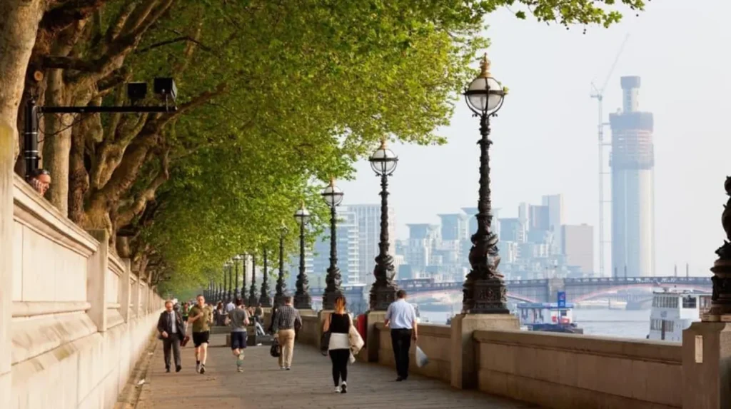
Albert Embankment is one of the most accessible places to begin a riverside walk. It extends along the Thames between Westminster Bridge and Vauxhall Bridge. The route includes landscaped spaces, historic embankment structures and views across the river.
Lambeth Bridge provides a useful reference point for visitors. It connects the borough with Westminster and offers views towards the Palace of Westminster, the London Eye and surrounding riverside architecture.
Walking south-east from the bridge brings visitors towards the St Thomas’ Hospital complex and the wider Albert Embankment area. The hospital is an important landmark in Lambeth’s riverside development.
Vauxhall Bridge marks another significant point along the river. Its architecture, nearby public spaces and connections with Vauxhall transport facilities make it a useful destination for walkers.
The Thames Path also connects these locations with a much longer walking network. Transport for London describes the Thames Path as a 79.5-mile (128-kilometre) route extending between the Richmond area and the eastern marshes. Its sections include both banks of the Thames.
Visitors do not need to complete the entire national trail to enjoy Lambeth’s riverside environment. Short walks between the bridges provide opportunities to explore the borough at a relaxed pace.
What Can Visitors Discover at Albert Embankment?
Albert Embankment is a historic riverside area in Lambeth featuring pedestrian spaces, Victorian infrastructure, St Thomas’ Hospital and modern developments. Visitors can walk beside the Thames, enjoy views of Westminster and examine how nineteenth-century engineering transformed London’s riverfront.
Albert Embankment is one of the most important locations for understanding Lambeth’s relationship with the River Thames.
The embankment forms part of the borough’s historic river frontage. Its development reflects the nineteenth-century transformation of London’s waterfront, when improvements to infrastructure, sanitation and public access changed the appearance of the capital.
Lambeth Council recognises Albert Embankment as a conservation area. The designation was first established on 26 November 2001, with boundary changes made in July 2016.
The conservation area includes the embankment walk, retaining walls, open spaces and nineteenth- and twentieth-century developments. St Thomas’ Hospital is its most significant architectural complex. Lambeth Council
The area offers several attractions for visitors.
Riverside walking: The pedestrian route provides opportunities to explore the Thames without leaving the central London environment.
Architectural landmarks: St Thomas’ Hospital and nearby buildings demonstrate different periods of London’s architectural development.
Historic infrastructure: The embankment walls, lamp standards and benches preserve elements of the area’s nineteenth-century character.
City views: Visitors can photograph the Houses of Parliament, Westminster Bridge and the surrounding riverfront.
Albert Embankment also provides access to smaller landscaped spaces. These create places to pause during longer walks and enjoy the changing views across the river.
The area is suitable for independent visitors, photographers, architecture enthusiasts and people exploring London’s historic riverside districts.
Where Are Effra Quay and the Isle of Effra?
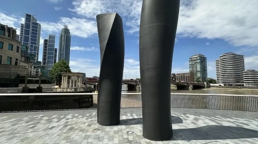
Effra Quay and the Isle of Effra are modern public riverside spaces in Vauxhall, located along Albert Embankment. They offer seating, accessible walking areas, public artwork and views of the Thames, connecting Lambeth’s hidden river heritage with its modern waterfront.
Effra Quay and the Isle of Effra are particularly relevant to visitors interested in the relationship between Lambeth’s historic waterways and contemporary urban regeneration.
Both spaces were created through the Thames Tideway Tunnel project. The project involved major improvements to London’s sewer infrastructure and the creation of new public spaces along the Thames.
Effra Quay provides an attractive riverside terrace with views towards the Houses of Parliament, the London Eye and Battersea Power Station. The Isle of Effra provides another public viewing space near Vauxhall Bridge.
Their names reference the historic River Effra, which once flowed through South London before becoming part of the underground sewer system.
The spaces include several visitor facilities and features:
- Timber benches facing the river, providing places to sit and enjoy the waterfront.
- Granite paving, creating a distinctive landscaped riverside surface.
- Public artwork by Richard Wentworth, connecting contemporary art with the riverfront.
- Poetry installations featuring work from Dorothea Smartt’s Hidden Rivers, Hidden Times series.
- Level access and wheelchair-friendly seating arrangements.
The Thames Water project information identifies these locations as part of improvements to the Thames Path experience. The new spaces also help restore a continuous accessible section of the riverside route.
Location: Albert Embankment, London SE1 7TP.
Nearest transport: Vauxhall Underground and railway stations.
Visitors should follow local safety signs and remain on designated paths. The Thames is tidal and is not safe for swimming. Temporary restrictions also apply when maintenance or construction work affects individual areas.
These public spaces demonstrate how modern infrastructure projects can improve access to the river while preserving connections with local history.
What Is the River Effra and Where Did It Flow Through Lambeth?
The River Effra was a natural South London watercourse that flowed through areas including Brixton, Herne Hill, Kennington and Vauxhall. Urban development, pollution and Victorian sewer construction gradually concealed it, leaving its former route as an important part of Lambeth’s history.
The River Effra is one of London’s best-known lost rivers. A lost river is a natural watercourse that has been buried, redirected or incorporated into underground drainage and sewer systems.
Historically, the Effra flowed from the higher ground around Upper Norwood towards Vauxhall, where it reached the River Thames.
Its route passed through several locations associated with Lambeth’s development. These included West Norwood, Brixton, Brockwell Park, Herne Hill and the Kennington area.
The river influenced the geography of the surrounding landscape. Its valley affected road alignments, settlement patterns and the drainage of low-lying areas.
During the eighteenth century, much of the surrounding land remained rural. Streams, marshes and open fields formed part of the landscape between central London and the southern suburbs.
However, the expansion of residential development during the nineteenth century changed the river’s environment.
Housing, roads and commercial activities increased the volume of waste entering the watercourse. The Effra gradually became an open sewer in several sections.
Its poor condition created sanitation problems for nearby communities. The river was subsequently covered over in stages between approximately 1820 and 1860.
The introduction of Joseph Bazalgette’s Victorian sewer infrastructure further transformed the watercourse. By 1865, its outflow had been connected to London’s intercepting sewer network.
The river continued to influence the area even after its burial. Flooding occurred because underground drainage infrastructure remained vulnerable to heavy rainfall.
London Museum documents the Effra’s historical route, flooding problems and transformation into part of London’s sewer system. London Museum+1
For visitors, the Effra provides an opportunity to understand a less visible aspect of Lambeth’s geography. Its history also explains why modern streets and neighbourhoods sometimes preserve names connected to former waterways.
How Did the River Effra Influence Brixton and Kennington?
The Effra influenced the development of Brixton and Kennington through its natural drainage patterns, flooding and changing relationship with residential expansion.
In Brixton, the river once flowed through an area that experienced regular flooding. The road now known as Brixton Road developed in a landscape affected by the watercourse.
A particularly serious flood occurred in 1818. Historical accounts described the Brixton Washway as resembling a large lake after heavy rainfall.
The flood demonstrates how the river influenced everyday movement and settlement before modern drainage infrastructure was established.
The Effra also influenced the development of The Oval, the historic cricket ground in Kennington. According to London Museum, the seating banks constructed in 1880 used soil excavated when the river was covered.
This connection demonstrates how the buried river influenced the physical development of an important sporting landmark. London Museum+1
Can Visitors Still See Evidence of the River Effra?
Visitors cannot follow the original river as an open waterway, but several historical clues remain across South London.
The most recognisable examples include street names, historical maps, underground drainage infrastructure and Victorian ventilation structures.
Brixton contains distinctive green sewer ventilation pipes often associated with the area’s former drainage system. These structures helped release gases from underground sewers.
Historical maps also help explain the river’s original route. The London Museum collection includes historical illustrations showing the rural landscape around Brixton before extensive urban development.
Visitors interested in this subject can combine a walk around Brixton with a visit to nearby Brockwell Park and Herne Hill.
This creates a broader understanding of how the natural landscape changed as South London became increasingly urbanised.
Which Riverside Gardens and Green Spaces Can Visitors Explore?
Visitors can explore Albert Embankment Gardens and the landscaped public spaces along the Thames in Vauxhall and central Lambeth. These locations provide seating, walking opportunities, river views and connections with nearby cultural attractions and historic landmarks.
Lambeth’s riverside environment includes several small green spaces that improve access to the Thames.
Albert Embankment Gardens is a useful starting point for visitors who want to combine riverside walking with time outdoors.
The gardens form part of a chain of small open spaces extending between Vauxhall and Waterloo. Their position beside the Thames provides views of central London’s historic skyline.
According to Lambeth’s film and location directory, Albert Embankment Gardens is open 24 hours a day. Film Lambeth
These gardens are particularly useful for visitors exploring the river on foot. They provide opportunities to stop, take photographs and enjoy the waterfront without needing to enter a commercial attraction.
The landscaped spaces near Effra Quay and the Isle of Effra provide additional seating and viewing opportunities.
For visitors interested in longer outdoor activities, the riverside connects with other walking destinations.
The South Bank is particularly accessible from Lambeth Bridge. Its pedestrian promenade includes cultural attractions, public artwork and historic buildings.
These spaces demonstrate the importance of public waterfront access in a densely developed urban borough.
What Makes the Riverside Environment Important for Visitors?
The riverside environment provides several benefits for people exploring Lambeth.
Walking routes connect different neighbourhoods without requiring extensive public transport journeys. Open spaces also create opportunities for short breaks between sightseeing activities.
The Thames provides a changing visual landscape. Visitors can observe river traffic, bridges, historic buildings and contemporary architecture from different positions along the embankment.
The public spaces also improve the relationship between residential developments and the natural environment.
For digital nomads and business travellers, the riverside provides outdoor spaces for breaks between work commitments. However, these are public recreational spaces rather than designated coworking facilities.
The combination of historic architecture, landscaped areas and accessible pedestrian routes makes the Thames frontage an important part of Lambeth’s visitor experience.
How Does the Thames Path Connect Lambeth With Other South London Attractions?
The Thames Path connects Lambeth’s riverside with wider South London walking destinations through a continuous network of sections and bridges. Visitors can explore Vauxhall, Battersea and neighbouring waterfront districts while discovering historic landmarks, parks and modern developments.
The Thames Path is one of the most important walking routes for visitors exploring London’s waterways.
It forms part of a wider National Trail and provides pedestrian access to riverside locations across the capital.
In Lambeth, the route connects the Albert Embankment area with the riverside around Vauxhall. It also provides access to routes extending towards Battersea and other neighbouring districts.
Transport for London identifies several sections of the Thames Path on the south bank, including routes between Putney Bridge and Battersea Park and between Albert Bridge and Tower Bridge. Transport for London
Visitors can use the following locations to plan a riverside exploration:
Lambeth Bridge: A useful starting point for exploring the historic waterfront and nearby Westminster landmarks.
Albert Embankment: A pedestrian-friendly riverside area with access to St Thomas’ Hospital and landscaped public spaces.
Vauxhall Bridge: An important river crossing with connections to Vauxhall’s transport facilities.
Effra Quay: A modern public space associated with the historic River Effra.
Battersea Park: A neighbouring riverside green space that provides additional walking opportunities.
A particularly useful route begins at Lambeth Bridge, follows Albert Embankment towards Vauxhall Bridge and continues towards the Battersea waterfront.
A local walking description from the Battersea Society identifies a route from the Isle of Effra to Battersea Park covering approximately 3.1 kilometres (1.9 miles). The route follows much of the Thames Path and includes riverside public spaces.
This route provides a practical option for visitors who want to explore more than one section of the Thames without planning a full-day excursion.
Can Visitors Explore the South Bank and Queen’s Walk From Lambeth?
Visitors can reach the South Bank from Lambeth Bridge and explore Queen’s Walk, a pedestrian promenade beside the River Thames. The route connects riverside viewpoints with cultural attractions, public art, restaurants and historic landmarks towards Blackfriars Bridge.
The South Bank is one of the most accessible neighbouring destinations for visitors exploring Lambeth’s waterways.
Queen’s Walk is a pedestrian promenade running along the southern bank of the Thames. It provides a direct connection between Lambeth’s riverside and central London’s cultural attractions.
The route begins near Lambeth Bridge and continues towards Blackfriars Bridge. Visitors can enjoy views across the river while exploring public spaces and cultural destinations.
Important attractions along this wider riverside area include:
- London Eye: A major observation attraction overlooking the Thames.
- Southbank Centre: A cultural complex hosting performances, exhibitions and public events.
- National Theatre: A prominent performing arts venue.
- Tate Modern: An international art museum located further east along the river.
- Festival Pier: A riverside transport and sightseeing location.
South Bank London describes the walk from Lambeth Bridge to Blackfriars Bridge as approximately 30 minutes without extended stops. South Bank London
This route is particularly suitable for tourists who want to combine sightseeing with outdoor activities.
The pedestrian promenade also provides opportunities for photography, riverside dining and observing London’s river traffic.
Visitors staying in Lambeth can use the bridges to cross between the borough and neighbouring Westminster attractions. This makes the South Bank an easy addition to a wider Lambeth itinerary.
How Did Lambeth’s Waterways Influence the Borough’s Historical Development?
Lambeth’s waterways influenced settlement, transport, industry, sanitation and urban expansion. The River Thames supported commercial activity and river crossings, while smaller rivers such as the Effra shaped local drainage, road development and the growth of residential neighbourhoods.
Waterways played an important role in the development of Lambeth long before the borough became part of modern London.
The River Thames provided a major transport corridor. Boats carried passengers and goods between riverside settlements and commercial districts.
Its position also influenced the development of bridges, docks, industrial buildings and public infrastructure.
Lambeth’s river frontage gradually became an important location for hospitals, housing, manufacturing and other urban activities.
The construction of Albert Embankment changed the relationship between the borough and the river. Its engineering and public-space improvements reflected wider nineteenth-century efforts to improve London’s infrastructure.
The history of smaller watercourses was equally important.
The River Effra once drained parts of South London and influenced the development of settlements around Brixton and Herne Hill. As population levels increased, the river became heavily polluted and was incorporated into the sewer network.
The development of underground drainage infrastructure changed the environmental conditions of the borough and supported further urban expansion.
Visitors exploring modern Lambeth therefore encounter a landscape shaped by several generations of water-related development.
As you explore the modern Thames waterfront, you are also crossing land with a deep industrial, environmental and social heritage. Discover the full [History of Lambeth’s River Thames and Waterways] to understand how rivers and historic watercourses influenced the borough’s development.
This historical connection provides context for understanding modern landmarks, including bridges, embankments, public gardens and regenerated riverside developments.
Are There Any Former Canals Near Lambeth?
Lambeth is better known for its river heritage than for operational canals. However, the wider South London area contains the former Grand Surrey Canal, which connected historic commercial districts and influenced the development of surrounding neighbourhoods.
Visitors searching for traditional canal towpaths should understand the geographical distinction between Lambeth and neighbouring South London districts.
The Grand Surrey Canal was an important historic waterway serving the industrial and commercial areas south of the Thames.
The Grand Surrey Canal Act of 1801 authorised its construction from Surrey Commercial Docks towards Epsom. The first dockland section opened in 1807, followed by a section reaching Camberwell Basin and a branch towards Peckham in 1809.
The canal transported raw materials using small tugs and horse-drawn barges. It supported commercial activity in areas connected to London’s historic docklands.
During the Second World War, industrial destruction affected businesses along the canal. Its commercial importance subsequently declined.
Draining began during the 1960s, and the canal was decommissioned and filled in during the 1970s.
Lewisham Council’s historical information documents the canal’s development and its later transformation into urban land. Lewisham Council
The former canal is useful for understanding the wider industrial geography of South London, but it should not be confused with Lambeth’s open waterways.
For visitors, the River Thames remains the most practical destination within Lambeth for exploring water-related heritage.
The former Grand Surrey Canal offers additional historical context for people interested in the wider development of South London.
What Is the Best Time to Explore Lambeth’s Waterways?
Spring, summer and early autumn provide suitable conditions for exploring Lambeth’s riverside routes. Longer daylight hours support walking and photography, while winter visits offer quieter surroundings. Visitors should check weather conditions, river safety information and temporary path restrictions before travelling.
The best time to explore Lambeth’s waterways depends on the activities visitors want to enjoy.
Spring provides opportunities to explore riverside gardens and landscaped public spaces as vegetation develops. Comfortable daytime conditions also support longer walking routes.
Summer offers extended daylight hours and opportunities to combine sightseeing with outdoor dining and photography. The Thames waterfront attracts people walking between Vauxhall, Westminster and Battersea.
Autumn provides changing colours in landscaped spaces and a quieter environment for exploring historic locations.
Winter visitors can still enjoy the Thames Path and public viewing areas. However, shorter daylight hours, rain and colder temperatures require suitable clothing and route planning.
Visitors should also consider tidal conditions. The Thames is a tidal river, and its water levels change throughout the day.
Swimming is unsafe in the tidal Thames. People should remain on designated pedestrian routes and follow local safety notices.
The new riverside spaces at Effra Quay and the Isle of Effra also have site-specific safety information. Temporary closures or restrictions apply when maintenance and other operational activities affect public access.
How Can Visitors Reach Lambeth’s Waterways Using Public Transport?
Visitors can reach Lambeth’s riverside attractions through nearby Underground, railway and bus connections. Vauxhall, Waterloo and Lambeth North provide useful transport access, while nearby river crossings connect the borough with Westminster and other central London destinations.
Lambeth benefits from several public transport connections that make its waterways accessible to tourists and residents.
Vauxhall Station is particularly useful for visiting Effra Quay, the Isle of Effra and Albert Embankment. It provides Underground and National Rail services.
Waterloo Station provides access to the South Bank and nearby riverside walking routes. It is also a major railway interchange for visitors travelling from other parts of London and the UK.
Lambeth North Station provides another option for visitors exploring central Lambeth and the surrounding attractions.
Westminster Station is useful for people approaching the Thames from the opposite bank. Lambeth Bridge provides a pedestrian connection between the two areas.
Visitors should consider the distance between their chosen transport station and the riverside destination. Some locations involve additional walking along busy roads.
Cycling is another option for exploring the wider Thames Path network. However, visitors should follow local route signs and respect pedestrian-priority sections.
Public transport is generally a practical choice because parking close to central London riverside attractions is limited.
Why Are Lambeth’s Waterways Important for Future Urban Development?
Lambeth’s waterways remain important for environmental improvement, public access, sustainable transport and urban regeneration. New riverside spaces and infrastructure projects demonstrate how the borough can protect its relationship with the Thames while supporting residential and commercial development.
Lambeth’s relationship with water continues to influence its development.
Modern regeneration projects increasingly recognise the importance of public access to riverside environments. Waterfront spaces provide recreational opportunities and improve connections between residential neighbourhoods and central London.
The Thames Tideway Tunnel project demonstrates this approach. Alongside improvements to London’s sewer infrastructure, the project has helped create public riverside spaces, including Effra Quay and the Isle of Effra.
These developments provide several long-term benefits.
Environmental improvement: Modern sewer infrastructure helps address the problem of untreated sewage entering the Thames during periods of heavy rainfall.
Public accessibility: Improved pedestrian routes connect visitors with previously restricted or less accessible sections of the waterfront.
Urban regeneration: New public spaces improve the relationship between residential developments, transport infrastructure and the river.
Cultural heritage: Public artwork and historical references preserve connections with London’s lost rivers and historic waterfront communities.
Outdoor recreation: Landscaped terraces, seating and pedestrian routes support walking and other outdoor activities.
The future of Lambeth’s waterways also depends on flood management and environmental protection.
Lambeth Council identifies different sources of flooding, including surface-water flooding, sewer flooding and flooding associated with rivers. Its guidance explains that the Thames and the River Graveney are the borough’s open rivers, while other historical watercourses have been buried. Lambeth Council+1
Climate change, intense rainfall and pressure on urban drainage systems make these issues increasingly relevant to future planning.
For visitors, these developments mean that Lambeth’s waterfront remains an evolving destination. Its importance extends beyond sightseeing to environmental management, infrastructure and public access.
Explore More Area Guide
How to Discover Lambeth’s Wildlife Habitats and Nature Reserves
Best Panoramic Views in Lambeth: Top London Viewpoints
What Should Visitors Include in a Lambeth Waterways Walking Itinerary?
A Lambeth waterways itinerary should include Lambeth Bridge, Albert Embankment, Effra Quay, the Isle of Effra and Vauxhall Bridge. Visitors can extend their walk towards Battersea or the South Bank to explore additional riverside attractions.
A self-guided walking itinerary provides a convenient way to explore Lambeth’s riverside heritage.
The following route combines historic landmarks, modern public spaces and views of the Thames.
Suggested Lambeth riverside walking route
- Lambeth BridgeBegin with views of Westminster and the historic Thames waterfront.
- Albert EmbankmentExplore the historic embankment, St Thomas’ Hospital and riverside architecture.
- Effra QuayDiscover the landscaped public space associated with the historic River Effra.
- Isle of EffraEnjoy the river views, seating and public artwork.
- Vauxhall BridgeFinish with architectural views and connections to Vauxhall.
Recommended walking route
Allow approximately 1–1.5 hours, depending on walking speed and sightseeing stops. Check local access conditions before setting out.
Visitors with additional time can extend their journey towards Battersea Park or return north towards Lambeth Bridge.
Another option is to explore the South Bank from Lambeth Bridge, following Queen’s Walk towards the National Theatre and Tate Modern.
These routes provide different perspectives on London’s waterfront. They also allow visitors to combine historical exploration with contemporary cultural attractions.
For photographers, the bridges and riverside terraces provide opportunities to capture London’s skyline from different angles.
For residents, the routes offer accessible outdoor activities close to established neighbourhoods.
For business travellers, a short riverside walk provides an opportunity to explore Lambeth between meetings or other commitments.
Where Can Visitors Explore Lambeth’s Canals and Waterways?
Lambeth offers a distinctive waterway experience centred on the River Thames and the history of its former rivers. Although the borough does not contain an extensive network of operational canals, its riverside paths, historic embankments and modern public spaces provide several opportunities for exploration.
Albert Embankment, Lambeth Bridge, Vauxhall Bridge, Effra Quay and the Isle of Effra are among the most relevant destinations for visitors interested in Lambeth’s waterways.
The River Effra adds another important historical dimension. Its buried course demonstrates how urban expansion, sanitation improvements and infrastructure development transformed South London’s natural landscape.
Visitors can combine these locations with the Thames Path, nearby South Bank attractions and neighbouring riverside parks to create a broader walking itinerary.
Lambeth’s waterways therefore represent more than geographical features. They explain the borough’s historical development, support its modern public spaces and continue to influence its environmental and urban future.
Does Lambeth have any canals?
Lambeth does not have an extensive network of operational canals. Its main waterway attraction is the River Thames, alongside historic waterways such as the buried River Effra.