London’s postwar reconstruction transformed Lambeth through new housing estates, redesigned roads, civic buildings, cultural institutions and the redevelopment of bomb-damaged neighbourhoods. The borough provides a useful way to understand how post-1945 planning reshaped the capital, from the South Bank’s cultural renewal to modernist housing in Brixton and the rebuilding of central districts.
- How did the Second World War change Lambeth’s urban landscape?
- What does the South Bank reveal about postwar redevelopment?
- How does County Hall connect Lambeth with postwar reconstruction?
- Which Lambeth housing estates explain postwar architectural planning?
- What does Brixton Recreation Centre reveal about postwar civic design?
- How does 269 Leigham Court Road demonstrate postwar social housing design?
- What does Akerman Road reveal about rebuilding bomb-damaged homes?
- How does the South Bank’s modern architecture differ from traditional Lambeth streets?
- How can visitors plan a Lambeth postwar reconstruction walk?
- Why does Lambeth’s postwar reconstruction remain relevant today?
- Which Lambeth locations best explain London’s postwar reconstruction?
Lambeth helps explain London’s postwar reconstruction because its neighbourhoods reveal how planners, councils and public institutions responded to wartime destruction, housing shortages and changing transport needs. The borough connects major rebuilding projects with everyday residential streets, public spaces and cultural developments across South London.
London faced extensive reconstruction after the Second World War ended in 1945. German bombing damaged homes, industrial buildings, railway infrastructure and commercial districts. The destruction intensified a housing shortage that had already developed through overcrowding, poor-quality accommodation and population pressure.
Lambeth, on the south bank of the River Thames, offers several ways to examine this period. Its northern boundary faces Westminster, while neighbourhoods such as Brixton, Kennington, Stockwell and Vauxhall demonstrate different approaches to housing, transport and public services.
Postwar reconstruction did not mean rebuilding every damaged building in its original form. Architects and planners increasingly considered modern housing standards, sunlight, open space, road capacity and access to public facilities. These priorities influenced the design of council estates, civic developments and major urban projects.
The term postwar reconstruction describes the physical and social rebuilding undertaken after a war. In London, it included repairing damaged buildings, constructing replacement homes, reorganising streets and improving infrastructure. The process continued for decades rather than ending in the immediate aftermath of 1945.
Lambeth’s present-day landscape reflects this extended history. Some sites demonstrate modernist architectural principles, while others illustrate the conservation of older buildings alongside contemporary development.
How did the Second World War change Lambeth’s urban landscape?
The Second World War changed Lambeth through bombing damage, displaced residents, housing shortages and pressure on essential services. Reconstruction addressed these problems through new homes, improved infrastructure and revised planning priorities, while older streets and surviving buildings continued to shape the borough’s development.
Lambeth occupied an important position in wartime London because it contained residential districts, railway connections, industrial premises and routes linking central London with southern suburbs. Bombing affected parts of the borough, although the scale and pattern of damage varied considerably between neighbourhoods.
The wider Blitz, which began in September 1940, brought repeated air raids to London. Residential streets and infrastructure suffered damage, and families faced displacement or the loss of their homes. Wartime restrictions also limited the construction of new housing, allowing shortages to deepen.
After 1945, local authorities confronted several connected challenges. They needed to provide accommodation, replace unsafe buildings, restore services and accommodate a population requiring better living conditions.
Reconstruction also reflected changing expectations about housing. Many prewar properties lacked indoor bathrooms, adequate space or modern heating. Postwar housing programmes promoted improved sanitation, separate rooms, better access to daylight and planned communal areas.
What did postwar planning aim to achieve?
The reconstruction programme combined immediate repairs with longer-term urban planning. Councils and national government bodies sought to increase housing supply and improve public health through building regulations, redevelopment schemes and investment in infrastructure.
The Town and Country Planning Act 1947 established a major framework for modern British planning. It introduced a development control system and strengthened public oversight of land use. Its effects extended beyond Lambeth, influencing how local authorities assessed development proposals and planned urban growth.
The New Towns Act 1946 also shaped the wider response to London’s housing pressures. New towns outside the capital offered opportunities to accommodate population growth, while inner London boroughs continued to replace damaged homes and improve existing neighbourhoods.
These policies did not produce a single uniform architectural style. Lambeth developed through a mixture of traditional street layouts, postwar council housing, commercial redevelopment and later regeneration projects.
What does the South Bank reveal about postwar redevelopment?
The South Bank reveals how postwar London used cultural investment and modern architecture to reshape an underused riverside district. The 1951 Festival of Britain established a new public identity for the area, with the Royal Festival Hall becoming its most important permanent cultural building.
The South Bank is one of the clearest places to begin a reconstruction-focused visit to Lambeth. The area lies along the River Thames near Waterloo and faces Westminster across the water.
Before its postwar transformation, parts of this riverside district contained industrial premises, railway infrastructure and utilitarian buildings. The redevelopment programme introduced a different emphasis: cultural institutions, public access and modern architectural design.
The Festival of Britain opened in 1951 as a national exhibition celebrating British achievements in science, industry, design and the arts. Its South Bank site presented a vision of postwar Britain that focused on innovation and improved public life.
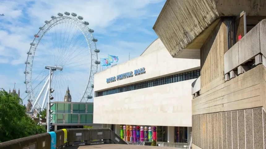
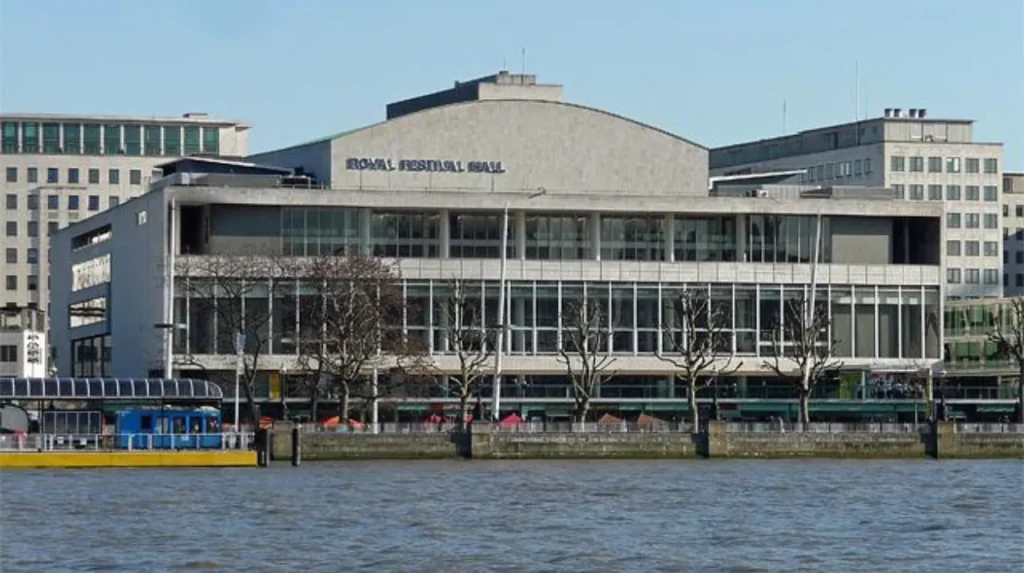
The Royal Festival Hall was the festival’s principal permanent building. Construction began in 1949, and King George VI officially opened the hall on 3 May 1951. The venue subsequently became a major concert hall and the foundation of what developed into the Southbank Centre.
The wider cultural complex expanded during the 1960s. The Queen Elizabeth Hall, Purcell Room and Hayward Gallery formed part of a new generation of modernist buildings. Their exposed concrete, geometric forms and functional layouts demonstrate the architectural approaches associated with the period.
How can visitors explore the South Bank’s architectural history?
Visitors can walk along the riverside and examine the relationship between the cultural buildings, pedestrian spaces, bridges and surrounding streets. The South Bank Conservation Area, designated in 1982 and subsequently extended, protects a nationally important collection of twentieth-century buildings. Lambeth Council identifies the Royal Festival Hall as a central element of the area’s development.
The route also demonstrates how postwar development evolved beyond its original purpose. The Southbank Centre now accommodates concerts, exhibitions, festivals and public activities. Its archive preserves programmes, photographs, architectural plans and other records that document changes to the site since 1951.
For visitors interested in urban history, the South Bank provides direct evidence of how cultural infrastructure became part of London’s reconstruction strategy.
How does County Hall connect Lambeth with postwar reconstruction?
County Hall connects Lambeth’s reconstruction story with the civic administration that shaped London before and after the Second World War. Although the building predates the war, its position beside the Royal Festival Hall helps explain the transition from older government architecture to modern postwar cultural development.
County Hall stands beside the Thames near Westminster Bridge. Completed in stages during the early twentieth century, it served as the headquarters of the London County Council (LCC), the authority responsible for many metropolitan public services before the creation of the Greater London Council in 1965.
The building is not itself a postwar reconstruction project. Its importance lies in the institutional context it provides. The London County Council played a significant role in housing provision, public infrastructure and urban planning during the period when London was responding to wartime damage and long-standing overcrowding.
The contrast between County Hall and the neighbouring Royal Festival Hall is especially useful. County Hall represents an earlier tradition of monumental civic architecture. The Royal Festival Hall represents a postwar approach that placed modern design and cultural provision at the centre of urban renewal.
The surrounding riverside also shows how major buildings from different decades became part of one urban landscape. The South Bank Conservation Area includes County Hall alongside buildings associated with postwar reconstruction.
Visitors examining the two buildings can consider how London’s public institutions changed their priorities. Civic administration, housing provision, cultural facilities and public access all contributed to the city’s changing relationship with its riverfront.
Which Lambeth housing estates explain postwar architectural planning?
Lambeth’s postwar housing estates demonstrate how local authorities addressed housing shortages through high-rise blocks, low-rise high-density layouts and purpose-designed homes. Cressingham Gardens, Central Hill and other council housing schemes show how architects tested different approaches to community life, open space and residential design.
Lambeth became an important centre for public housing innovation during the decades following the creation of the modern London borough in 1965. Historic England’s research into Lambeth housing between 1965 and 1980 documents the range of schemes developed during this period. These included prefabricated tower blocks, low-rise high-density estates and refurbishment projects that retained elements of existing neighbourhoods.
A major figure in this development was Ted Hollamby, the architect and planner who led Lambeth’s Department of Architecture and Planning after moving from the London County Council’s architect department in 1963. Under his leadership, the borough developed housing schemes with varied layouts and facilities for different household needs.
Why is Cressingham Gardens important?
Cressingham Gardens is a low-rise housing estate associated with Lambeth’s experiments in residential design. Its architecture provides an alternative to the high-rise model frequently associated with postwar redevelopment.
Low-rise high-density housing accommodates a substantial number of residents without relying exclusively on tall blocks. The approach uses building arrangement, shared spaces, walkways and carefully planned layouts to balance density with access to outdoor areas.
Historic England’s research examines the estate within the wider history of public housing and the architectural ideas that influenced Lambeth during the 1960s and 1970s. The estate also became the subject of a long-running dispute over demolition, refurbishment and the preservation of its architectural character.
What does Central Hill reveal about postwar housing?
Central Hill offers another perspective on Lambeth’s modern housing history. Alongside Cressingham Gardens, it illustrates the architectural diversity of estates developed during a period when councils sought alternatives to older overcrowded housing.
In October 2026, reporting indicated that plans to demolish Cressingham Gardens and Central Hill were expected to be reversed following a change in the council’s political leadership. The estates therefore illustrate a continuing issue in postwar urban planning: how to balance the need for suitable housing with the conservation of architecturally significant social housing.
These estates are residential communities rather than conventional tourist attractions. Visitors should respect residents’ privacy and use public streets and authorised routes when examining the architecture.
What does Brixton Recreation Centre reveal about postwar civic design?
Brixton Recreation Centre illustrates how Lambeth extended postwar planning beyond housing to include sport, leisure and community facilities. Designed in 1970 by a team led by George Finch, with Ove Arup and Partners as consulting engineers, it combines recreation provision with an urban building form.
Brixton Recreation Centre is a significant landmark in Lambeth’s twentieth-century architectural history. Its design belongs to the period when local authorities invested in facilities intended to support everyday community life.
The building’s history demonstrates that reconstruction involved more than replacing damaged houses. Public investment also addressed recreation, physical activity and access to communal services. These facilities formed part of a wider approach to improving urban living standards.
Its design dates from 1970, when modernist architecture was prominent in public buildings. Modernism generally emphasised functional planning, structural clarity and the use of contemporary materials. In civic architecture, these principles supported buildings designed around specific activities rather than traditional decorative forms.
Brixton’s surrounding streets provide further context. The neighbourhood developed through successive periods of housing construction, commercial activity, migration and cultural change. The recreation centre sits within this layered urban environment rather than representing an isolated redevelopment project.
The building is recorded in Historic England’s Lambeth heritage collection. That recognition provides a starting point for understanding its architectural significance and its place within the borough’s postwar development.
For visitors, the centre helps connect architectural history with the social purpose of public buildings. It also shows why postwar planning must be examined through the facilities residents used, not only through prominent monuments or residential towers.
How does 269 Leigham Court Road demonstrate postwar social housing design?
The sheltered housing scheme at 269 Leigham Court Road demonstrates how postwar public housing addressed the needs of older residents. Designed by architect Kate Macintosh between 1968 and 1973, the Grade II-listed development combines individual flats, gardens, shared facilities and covered walkways.
This development provides a more specialised example of postwar housing policy. Rather than accommodating households of all ages in a general council estate, the scheme was designed specifically for older residents who required independent accommodation with communal support.
Kate Macintosh designed the development for Lambeth Borough Council. Historic England describes seven blocks arranged along a long, narrow site, with gardens and a covered walkway connecting the buildings. The scheme contains 44 flats and shared facilities that include a common room, laundry and guest room.
The layout illustrates how architects considered the daily experience of residents. The covered walkway provides sheltered movement between buildings, while gardens create outdoor space within the development. Shared facilities support practical needs and opportunities for interaction.
The project also reflects a wider shift in social policy. Postwar public housing increasingly recognised that accommodation needed to serve different stages of life. Purpose-designed housing for older people formed part of this developing welfare-state approach.
Historic England lists 269 Leigham Court Road at Grade II, citing its architectural quality, planning interest and importance in the history of sheltered housing. Its relatively well-preserved design makes it a valuable reference point for studying residential architecture from the late 1960s and early 1970s.
The site is primarily a residential development, so visits should remain respectful of occupants. Its significance is best understood through the published heritage record and the publicly accessible surrounding streets.
What does Akerman Road reveal about rebuilding bomb-damaged homes?
Akerman Road in North Lambeth shows how the legacy of wartime damage continued to influence housing decisions decades after 1945. The redevelopment combined new council homes with the repair and replacement of older buildings, demonstrating how reconstruction remains connected to existing neighbourhoods.
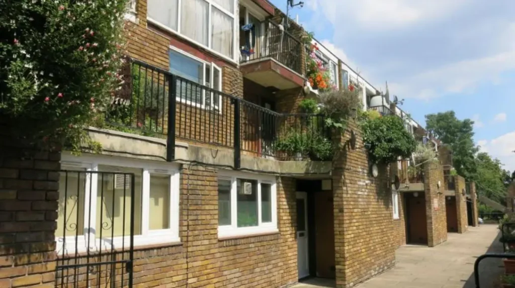
Akerman Road, in the Vassall ward of North Lambeth, provides a useful example of how housing development can respond to historic damage without removing an entire street.
In January 2017, Lambeth Council reported that a new development had created nine council homes. Three four-bedroom houses were incorporated into a Victorian terrace damaged by Second World War bombing. The project also included Passivhaus-standard construction for those houses.
The Passivhaus standard is a building approach designed to reduce energy demand through features such as effective insulation, airtight construction and controlled ventilation. Its inclusion demonstrates how contemporary housing standards can be applied to properties within a historic urban setting.
Akerman Road is important because it connects two different periods of public policy. The wartime damage explains the need for replacement housing, while the modern development reflects later priorities such as energy efficiency and the provision of council accommodation.
It also challenges the idea that postwar reconstruction happened in one concentrated building programme. Some damaged sites remained part of the urban landscape for decades before receiving new investment.
How should visitors interpret the street’s architectural layers?
Visitors can observe the relationship between older terraces and later housing, where publicly accessible views allow. The wider streetscape demonstrates how London neighbourhoods retain evidence of several building periods.
The best historical interpretation combines the visible architecture with council records and historic photographs. These sources help establish which buildings survived, which were altered and how later projects addressed earlier damage.
How does the South Bank’s modern architecture differ from traditional Lambeth streets?
The South Bank’s modern architecture differs from Lambeth’s traditional streets through its emphasis on large-scale public buildings, geometric forms and planned cultural spaces. Traditional terraces, meanwhile, reflect incremental residential development, narrow plots and established street patterns that predate the postwar planning period.
The contrast between these environments helps visitors recognise how reconstruction altered the scale and organisation of parts of London.
Traditional terraces developed through successive phases of nineteenth- and early twentieth-century urban growth. They generally follow the street frontage, with individual houses arranged in continuous rows. Their architecture reflects established property boundaries and the gradual expansion of residential districts.
Postwar modernist developments frequently adopted a different approach. Buildings were arranged around circulation routes, open spaces or shared facilities rather than following the existing street frontage. Large institutional buildings also occupied sites that allowed more extensive architectural forms.
The South Bank provides a particularly clear example because its cultural buildings were planned as a group. The Royal Festival Hall, Queen Elizabeth Hall and Hayward Gallery demonstrate the movement towards modernist public architecture during the 1950s and 1960s.
The contrast does not mean that traditional buildings belong to the past and modern buildings to the present. Both remain active parts of Lambeth’s urban environment. Their coexistence shows how reconstruction involved selective redevelopment rather than the complete replacement of historic streets.
What architectural features should visitors look for?
Look at building height, materials, window arrangements, entrances and the relationship between buildings and public space. These features help distinguish a modernist civic building from a Victorian terrace or a low-rise housing estate.
Concrete surfaces, large structural forms and deliberately arranged pedestrian spaces are common features of many postwar public developments. Traditional terraces generally display repetitive façades, brickwork and direct entrances from the pavement.
These differences provide a practical framework for examining Lambeth without requiring specialist architectural knowledge.
How can visitors plan a Lambeth postwar reconstruction walk?
A Lambeth reconstruction walk works best when it connects the South Bank’s cultural buildings with selected housing and civic landmarks. Visitors can begin near Waterloo, examine the riverside architecture, then travel south to Brixton or other neighbourhoods to compare public buildings and residential developments.
The South Bank is the most practical starting point because several significant buildings stand within walking distance of Waterloo Station. The Royal Festival Hall, Queen Elizabeth Hall and Hayward Gallery form a compact architectural group, while County Hall provides an earlier civic reference point.
A useful visit can be organised into three stages.
First, examine the South Bank’s cultural redevelopment. Observe the buildings’ relationship to the river, their modernist forms and the public spaces surrounding them.
Second, travel to Brixton to explore the architectural context of Brixton Recreation Centre and consult the borough’s heritage resources. Lambeth Archives, at 16 Brixton Hill, holds local historical material and has hosted exhibitions on the borough’s public housing between 1965 and 1980. Exhibition dates and access arrangements should be checked before travelling.
Third, select a residential example such as the area around Cressingham Gardens or Leigham Court Road. These sites help explain the different approaches architects used when designing homes for families and older residents.
Not every residential landmark is open to the public. Visitors should use public pavements, follow access restrictions and avoid entering communal courtyards or private estate facilities without permission.
Where can visitors find reliable historical information?
Lambeth Council’s conservation-area profiles provide information about protected districts and the architectural characteristics of individual sites. Historic England’s local heritage hub identifies listed buildings and offers historical photographs and other resources.
These resources are particularly valuable when a building’s present appearance does not reveal its original purpose. Historic photographs also help visitors compare the modern streetscape with earlier phases of development.
For the South Bank, the Southbank Centre archive preserves material relating to the Festival of Britain, architectural projects and the site’s cultural history.
Explore More Area Guide
Lambeth Public Services: Landmarks, History and Visitor Guide
Where to Discover Lambeth’s Religious Heritage in South London
Why does Lambeth’s postwar reconstruction remain relevant today?
Lambeth’s postwar reconstruction remains relevant because the borough continues to address housing demand, building conservation, energy efficiency and the future of public space. Its historic estates and cultural landmarks show how earlier planning decisions influence present-day regeneration and debates about the value of existing buildings.
The long-term impact of reconstruction is visible in the way Lambeth manages its built environment. Housing estates designed in the 1960s and 1970s now require decisions about maintenance, accessibility, energy performance and the needs of changing households.
Cressingham Gardens and Central Hill illustrate the difficulty of balancing new housing provision against the architectural and social value of existing estates. The 2026 reporting on proposed changes to demolition plans shows that these decisions remain part of current local policy debates.
The South Bank presents a different challenge. Its cultural buildings continue to serve public audiences while requiring conservation, adaptation and investment. The area demonstrates how a postwar development can become an established part of London’s identity rather than remaining a temporary response to wartime conditions.
Akerman Road illustrates another continuing principle: historic damage and modern housing needs can be addressed through targeted development within an established neighbourhood. The project links the physical legacy of war with contemporary standards for council housing and energy efficiency.
These examples also demonstrate that reconstruction is not simply an architectural category. It includes public administration, housing policy, cultural investment, social provision and the conservation of buildings that have acquired historical significance.
Which Lambeth locations best explain London’s postwar reconstruction?
The South Bank, County Hall, Brixton Recreation Centre, Cressingham Gardens, Central Hill, 269 Leigham Court Road and Akerman Road provide complementary evidence of Lambeth’s postwar development. Together, these locations explain cultural renewal, modernist architecture, social housing and the continued adaptation of historic neighbourhoods.
The South Bank is the strongest starting point for understanding the cultural ambitions of postwar reconstruction. The Royal Festival Hall and neighbouring buildings show how investment in arts and public spaces transformed the riverside.
County Hall adds an institutional perspective by connecting the area with London’s earlier system of metropolitan government. Brixton Recreation Centre demonstrates the importance of leisure and community facilities, while Cressingham Gardens and Central Hill illustrate the variety of approaches to council housing.
The sheltered housing at 269 Leigham Court Road reveals how architects designed homes around the needs of older residents. Akerman Road demonstrates how new housing can respond to wartime damage while retaining elements of an established street.
For visitors seeking a deeper historical understanding, these sites are most useful when examined alongside archival records and planning documents. The full [Lambeth Historical Background and Urban Development Guide] explains the borough’s earlier growth and provides context for understanding its postwar transformation.
Lambeth’s reconstruction history ultimately reveals how London adapted to the consequences of war through architecture, housing, public institutions and cultural investment. The resulting buildings remain important evidence of the planning decisions that shaped the capital during the second half of the twentieth century.
Which Lambeth locations best explain London’s postwar reconstruction?
The South Bank, Royal Festival Hall, County Hall, Brixton Recreation Centre, Cressingham Gardens, Central Hill and 269 Leigham Court Road help explain Lambeth’s postwar development. These locations illustrate cultural redevelopment, modernist architecture, public housing and community facilities.