Lambeth offers some of the most distinctive panoramic viewpoints in South London. Its elevated parks, historic riverside promenades, observation attractions and open green spaces provide views across the River Thames, the City of London, Westminster and surrounding neighbourhoods. Visitors can experience the capital’s skyline from natural hillsides, landscaped gardens and purpose-built viewing platforms.
- What Makes Lambeth an Excellent Destination for Panoramic Views?
- How Does Lambeth’s Geography Influence Its Viewpoints?
- Why Are Panoramic Views Important to Lambeth’s Tourism?
- Which Parks Offer the Best Panoramic Views Across Lambeth and London?
- Brockwell Park: Where Can Visitors See Central London’s Skyline?
- Norwood Park: Where Can Visitors Enjoy Views Across South London?
- Streatham Common: Where Are the Best Views Across the Wandle Valley?
- How Do Brockwell Park, Norwood Park and Streatham Common Compare?
- Where Can Visitors Enjoy Panoramic Riverside Views in Lambeth?
- Albert Embankment: Where Can Visitors Photograph Westminster?
- Lambeth Bridge: What Can Visitors See From the River Crossing?
- Effra Quay and the Isle of Effra: What Makes These Riverside Spaces Special?
- Which Attractions in Lambeth Provide Elevated Views Across London?
- The London Eye: Why Is It One of London’s Most Recognisable Viewpoints?
- Garden Museum Medieval Tower: Can Visitors See London From This Historic Structure?
- Which Historic Locations Offer Interesting Views Across Lambeth?
- Lambeth Palace: What Can Visitors See Around This Historic Landmark?
- How Does St Thomas’ Hospital Contribute to the Albert Embankment Skyline?
- How Does Lambeth’s History Shape Its Panoramic Landscapes?
- What Are the Best Places for Photography and Sunset Views in Lambeth?
- Where Can Visitors Photograph London’s Skyline?
- Where Are the Best Places to Photograph the River Thames?
- When Is the Best Time to Enjoy Panoramic Views?
- How Can Visitors Plan a Panoramic Viewpoint Tour Around Lambeth?
- Which Transport Options Connect Lambeth’s Viewpoints?
- What Is a Practical One-Day Panoramic Viewpoint Itinerary?
- Are Lambeth’s Panoramic Viewpoints Suitable for Families?
- Are Lambeth’s Viewpoints Suitable for Wheelchair Users?
- How Do Lambeth’s Panoramic Viewpoints Support Tourism and the Local Environment?
- Why Are Public Parks Important for Protecting London’s Views?
- How Does Lambeth Protect Important Panoramic Views?
- What Is the Future of Panoramic Viewpoints in Lambeth?
- Which Places Should Visitors Prioritise for Panoramic Views in Lambeth?
The London Borough of Lambeth stretches from the River Thames in the north towards Norwood and Streatham in the south. Its varied landscape creates different opportunities for sightseeing and photography. Brockwell Park provides elevated views towards central London, Norwood Park overlooks parts of South London, and Streatham Common offers wide perspectives across the Wandle Valley.
The borough also includes prominent riverside locations such as Albert Embankment, Lambeth Bridge and the area surrounding the London Eye. These places offer a different perspective, with historic buildings, bridges and waterfront architecture forming the main visual features.
Understanding the best places to enjoy panoramic views in Lambeth helps visitors plan sightseeing trips, outdoor activities and photography excursions. It also introduces the area’s architectural heritage, public parks and relationship with the River Thames.
What Makes Lambeth an Excellent Destination for Panoramic Views?
Lambeth is an excellent destination for panoramic views because its landscape combines elevated public parks, historic riverside spaces and prominent observation attractions. These locations provide different perspectives across London’s skyline, Westminster, the Thames and South London’s residential neighbourhoods.
Lambeth occupies a varied geographical position within inner and outer South London. Its northern neighbourhoods sit alongside the River Thames, while its southern districts include higher ground, historic commons and extensive public parks.
This geographical variation creates several types of viewpoints. Visitors can look across London from elevated green spaces or observe major landmarks from the riverfront.
The borough’s most recognisable viewing environments include:
- Elevated parkland, including Brockwell Park and Norwood Park.
- Open commons, including Streatham Common.
- Riverside promenades, including Albert Embankment.
- Purpose-built observation attractions, including the London Eye.
- Historic waterfront settings, including the area surrounding Lambeth Palace and the Garden Museum.
Each location offers a different visual experience. Elevated parks provide longer-distance views across the city, while riverside locations bring visitors closer to historic architecture and the Thames.
How Does Lambeth’s Geography Influence Its Viewpoints?
Lambeth’s geography is particularly important because the borough includes both low-lying riverside areas and elevated southern districts.
The River Thames forms its northern boundary with Westminster. The river creates open viewing corridors towards important landmarks, including the Palace of Westminster, the Elizabeth Tower and the London Eye.
Further south, the terrain rises around Herne Hill, West Norwood and Streatham. These higher areas provide opportunities to view distant buildings and sections of the wider London skyline.
Brockwell Park and Norwood Park demonstrate how elevated public green spaces contribute to Lambeth’s landscape. Both locations appear in Lambeth Council’s planning material concerning important local views.
Why Are Panoramic Views Important to Lambeth’s Tourism?
Panoramic viewpoints contribute to Lambeth’s visitor economy by connecting sightseeing with outdoor recreation, heritage and photography.
Visitors can combine a walk through Brockwell Park with a visit to Brockwell Hall or the nearby Herne Hill neighbourhood. Similarly, a riverside walk around Albert Embankment connects visitors with Lambeth Palace, St Thomas’ Hospital and Westminster’s historic architecture.
These experiences support different visitor interests. Tourists explore London’s landmarks, residents enjoy accessible outdoor spaces, and photographers use elevated locations to capture the changing skyline.
Lambeth’s viewpoints also contribute to the borough’s environmental and architectural identity. Open spaces protect important landscape views and provide access to nature within a densely developed city.
Which Parks Offer the Best Panoramic Views Across Lambeth and London?
Brockwell Park, Norwood Park and Streatham Common are among Lambeth’s strongest outdoor viewpoints. Their elevated positions provide different panoramas across central London, South London and the Wandle Valley, with accessible public spaces for walking, photography and recreation.
Lambeth’s parks provide some of its most accessible opportunities to enjoy expansive views without purchasing attraction tickets.
Unlike enclosed observation platforms, these outdoor viewpoints allow visitors to experience the skyline alongside trees, open grassland, wildlife habitats and historic landscape features.
Brockwell Park: Where Can Visitors See Central London’s Skyline?
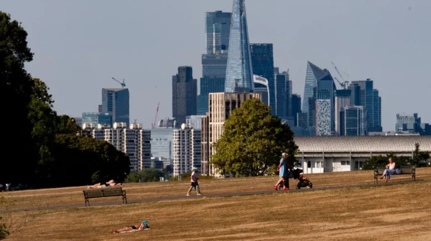
Brockwell Park is one of the most important panoramic viewpoints in Lambeth. Located between Herne Hill, Brixton and Tulse Hill, the park occupies an elevated landscape overlooking parts of central and northern London.
Its address is Norwood Road, Herne Hill, London SE24 9BJ.
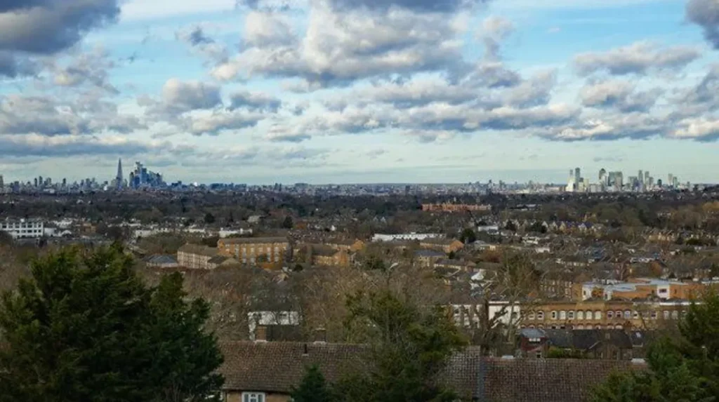
Lambeth Council identifies the hillside path running parallel to Dulwich Road as an important viewing location. This elevated route provides views towards the north and north-east, including the City of London.
Recognisable landmarks visible within the wider panorama include:
- The Shard, London’s prominent skyscraper near London Bridge.
- St Paul’s Cathedral, the historic cathedral designed by Sir Christopher Wren.
- The Gherkin, officially known as 30 St Mary Axe.
- The London Eye, the observation wheel on the South Bank.
- Strata SE1, a residential skyscraper near Elephant and Castle.
The view changes as visitors move along the hillside path. This creates a continuous viewing experience rather than a single fixed photographic position.
Brockwell Park is also historically significant. The estate was formerly the private residence of John Blades, a London glass merchant. The Metropolitan Board of Works acquired the land during the late nineteenth century, and the park opened to the public in 1892.
Its principal historic features include Brockwell Hall, the Brockwell Lido, the Walled Garden, ornamental ponds and the nineteenth-century Tritton Clocktower.
Brockwell Hall stands on the central hill and contributes to the park’s historic landscape. Visitors can combine sightseeing with walking, picnicking and exploring its landscaped gardens.
The park normally opens at 7.30am and closes 15 minutes before sunset. Visitors should check Lambeth Council’s current information before travelling.
Brockwell Park is particularly suitable for visitors seeking an elevated, natural viewpoint with a broad panorama of London’s architectural landmarks.
Norwood Park: Where Can Visitors Enjoy Views Across South London?
Norwood Park occupies one of the highest points in Lambeth and provides extensive views across South London. Its elevated position makes it an important destination for visitors seeking open landscapes and distant urban scenery.
The park is located at Salters Hill, West Norwood, London SE19 1DZ.
Lambeth Council identifies Norwood Park as a significant elevated public space. Its position provides opportunities to look across surrounding residential districts and parts of the wider South London landscape.
The park contains several facilities that support recreational visits:
- A children’s playground for families.
- An outdoor gym for exercise.
- A multi-use games area for sports.
- A skateboard park for recreational activities.
- A community garden and café.
- A wildlife pond and native hedges.
A tree-lined Country Walk provides a quieter route through the landscape. Visitors can enjoy the combination of mature vegetation, open grassland and distant urban views.
Norwood Park also has an interesting historical background. It formed part of Norwood Common, which belonged to the wider Great North Wood, an extensive historic woodland landscape across South London.
The area gradually experienced enclosure and urban development during the nineteenth century. The remaining public land eventually became a park.
The River Effra, one of London’s historic lost rivers, runs underground beneath part of the park. This adds another historical dimension to the location.
Norwood Park was formally declared a Local Nature Reserve on 3 March 2023. This designation recognises its importance for wildlife and public access to nature.
The park is open 24 hours a day according to Lambeth Council. Gipsy Hill railway station is approximately a 15-minute walk away.
Norwood Park is a strong choice for visitors seeking elevated South London views, outdoor recreation and a quieter alternative to central London’s major attractions.
Streatham Common: Where Are the Best Views Across the Wandle Valley?
Streatham Common provides some of Lambeth’s most distinctive natural panoramas. Its open hillside overlooks sections of the Wandle Valley and surrounding South London districts, with designated viewpoints offering opportunities to identify distant geographical features.
The common is located off Streatham High Road, London SW16 5NR.
The elevated slopes create a broad viewing environment. Visitors can look across grassland, woodland and residential areas towards the wider Wandle Valley landscape.
The Friends of Streatham Common organisation identifies several designated viewpoints across the common. These locations include benches and identification plates showing landmarks visible from particular positions.
Seven viewing seats with identification plaques were installed in spring 2000 as part of a Millennium project.
The common’s main attractions include:
- Open grassland and natural slopes.
- Woodland and wildflower meadows.
- Picnic areas and walking routes.
- A children’s playground and seasonal paddling pool.
- The Rookery, a historic formal garden.
- A café and public facilities.
The Rookery is particularly important for visitors interested in landscaped gardens. It contains formal planting, garden features and attractive views across its surroundings.
Streatham Common also has a connection with the Great North Wood, an extensive historic woodland landscape that once covered significant areas of South London.
Part of the common became a Metropolitan Common in 1884, protecting the land for public access and recreation.
The location forms part of the Capital Ring, a long-distance walking route around Greater London. This makes it suitable for visitors combining panoramic views with longer countryside-style walks.
Streatham Common is open 24 hours a day. Streatham and Streatham Common railway stations are both within walking distance.
Why visit? Streatham Common is particularly suitable for visitors interested in natural landscapes, designated viewing points, walking and long-distance views across the Wandle Valley.
How Do Brockwell Park, Norwood Park and Streatham Common Compare?
These three parks offer different perspectives because of their geographical positions and landscape characteristics.
Brockwell Park is best suited to visitors interested in the central London skyline. Its elevated hillside path provides a recognised panorama towards the City.
Norwood Park is particularly suitable for South London views and outdoor recreation. Its higher position creates a different perspective from the northern parts of Lambeth.
Streatham Common provides a more natural landscape experience. Its designated viewing points overlook the Wandle Valley and surrounding districts.
The choice depends on the type of scenery visitors want to experience. Those interested in skyscrapers and central London landmarks should prioritise Brockwell Park. Visitors seeking open green space should consider Norwood Park or Streatham Common.
Where Can Visitors Enjoy Panoramic Riverside Views in Lambeth?
Albert Embankment, Lambeth Bridge and the Thames waterfront provide some of Lambeth’s best riverside views. These locations offer open perspectives across Westminster, historic bridges, the Palace of Westminster and prominent London architecture along the River Thames.
The River Thames is one of the most important geographical and historical features of Lambeth.
Its northern waterfront provides a continuous relationship between the borough’s public spaces, historic buildings and central London’s landmarks.
Albert Embankment: Where Can Visitors Photograph Westminster?
Albert Embankment is one of Lambeth’s most recognisable riverside viewing locations. It runs along the southern bank of the River Thames between Vauxhall and Westminster Bridge.
The riverside promenade provides views towards the Palace of Westminster, Elizabeth Tower and other historic buildings on the opposite bank.
The location is especially suitable for photography because the river creates an open foreground. Visitors can photograph Westminster’s architecture alongside passing river traffic and the surrounding urban landscape.
Lambeth Council identifies Albert Embankment as part of Conservation Area CA57. The conservation area was first designated on 26 November 2001, with its boundary subsequently changed in July 2016.
The conservation area includes:
- The riverside embankment and retaining walls.
- Public open spaces and pedestrian routes.
- The historic St Thomas’ Hospital complex.
- Nineteenth- and twentieth-century developments.
- Important architectural and riverside viewing locations.
The Albert Embankment conservation area appraisal identifies the waterfront as an important place for appreciating the Westminster World Heritage Site.
Visitors can also observe Lambeth Palace, Vauxhall Bridge and the wider architectural character of the Thames waterfront.
Albert Embankment Gardens provide additional public space along the route. These gardens form a chain of small open spaces between Waterloo and Vauxhall.
The gardens are open 24 hours a day according to Lambeth Council.Albert Embankment is ideal for visitors seeking free riverside views, architectural photography and a convenient walking route between Vauxhall and Westminster.
Lambeth Bridge: What Can Visitors See From the River Crossing?
Lambeth Bridge offers elevated views along the River Thames and towards some of London’s most recognisable historic buildings.
The bridge connects Lambeth on the south bank with Westminster on the north bank. Its position provides a useful perspective of the Palace of Westminster, Lambeth Palace and surrounding riverside architecture.
The bridge is particularly valuable for understanding the relationship between the two sides of the Thames.
From the crossing, visitors can observe:
- The Palace of Westminster and Elizabeth Tower.
- Lambeth Palace, the historic London residence of the Archbishop of Canterbury.
- The riverside buildings surrounding Albert Embankment.
- River traffic travelling through central London.
- The wider architectural setting of Westminster.
Lambeth Bridge is also significant within the borough’s planning and conservation framework. Lambeth Council’s Albert Embankment Conservation Area appraisal identifies views from the bridge as important for appreciating nearby heritage buildings.
The bridge is a practical addition to a wider sightseeing walk. Visitors can approach it from Albert Embankment, cross towards Westminster and continue towards Parliament Square.
The best photographic opportunities occur when the river and surrounding architecture remain clearly visible.
Lambeth Bridge is a useful free viewpoint for visitors interested in London’s historic government district, riverside architecture and panoramic river scenes.
Effra Quay and the Isle of Effra: What Makes These Riverside Spaces Special?
Effra Quay and the Isle of Effra are public riverside spaces in Vauxhall created through the Thames Tideway Tunnel project.
Their position along Albert Embankment provides views of the Houses of Parliament, the London Eye and Battersea Power Station.
The spaces introduce a modern public-realm experience to Lambeth’s historic waterfront. Their design includes timber benches, granite paving, trees, seating and public artwork.
The two locations are named after the River Effra, one of London’s historic lost rivers. The Effra once flowed through areas of South London before becoming incorporated into the Victorian sewer network.
The new riverside spaces also improve the Thames Path experience by providing a wider and more accessible pedestrian route.
Their main features include:
- Seating facing the River Thames.
- Level-access public areas.
- Views towards Westminster and Battersea.
- Public artwork and poetry.
- Improved pedestrian connections along the waterfront.
Effra Quay and the Isle of Effra are particularly useful for visitors exploring Vauxhall. Their location near Vauxhall Underground and railway stations makes them convenient for public transport users.
The Thames is a tidal river, so visitors should remain on designated paths and follow safety signage.
Why visit? These spaces provide a modern, accessible riverside environment with views across several major London landmarks.
Which Attractions in Lambeth Provide Elevated Views Across London?
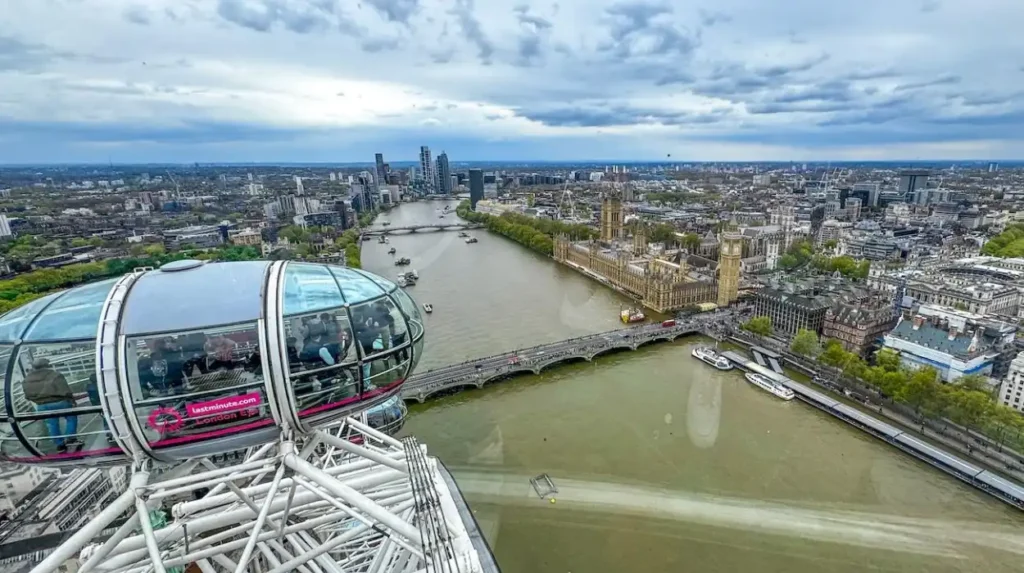
The London Eye is Lambeth’s best-known elevated observation attraction, offering a 360-degree panorama from 135 metres above the River Thames. The Garden Museum’s medieval tower also provides historic elevated views when its visitor access reopens.
Lambeth combines natural viewpoints with attractions that allow visitors to experience London from above ground level.
These attractions provide different viewing experiences. The London Eye offers a rotating observation experience, while the Garden Museum’s medieval tower connects panoramic sightseeing with the architectural history of the Thames waterfront.
The London Eye: Why Is It One of London’s Most Recognisable Viewpoints?
The London Eye is one of the most recognisable observation attractions in the United Kingdom. Located on the South Bank of the River Thames beside County Hall, it provides panoramic views across central London.
The attraction stands 135 metres high and features 32 observation capsules. Each capsule provides an enclosed viewing environment with extensive visibility across the surrounding city.
A complete rotation takes approximately 30 minutes.
The London Eye’s elevated position provides views of several major landmarks, including:
- The Palace of Westminster.
- Elizabeth Tower, commonly associated with Big Ben.
- Buckingham Palace.
- St Paul’s Cathedral.
- The Shard.
- Tower Bridge.
- Wembley Stadium.
The observation wheel opened in 2000 as part of the celebrations surrounding the new millennium. It subsequently became one of London’s most recognised visitor attractions.
The experience is particularly useful for visitors who want to understand London’s geography. From above, the River Thames provides a clear reference point for identifying different districts and landmarks.
The attraction is accessible from Waterloo station, approximately five minutes away on foot. Embankment, Charing Cross and Westminster stations also provide access.
Visitors need an admission ticket. Booking an allocated entry time in advance helps organise a sightseeing itinerary.
The London Eye operates throughout most of the year, although seasonal opening hours and maintenance closures apply. Visitors should check the official website before travelling.
Why visit? The London Eye is the strongest choice for visitors seeking an elevated, uninterrupted panorama of central London’s historic and modern skyline.
Garden Museum Medieval Tower: Can Visitors See London From This Historic Structure?
The Garden Museum occupies the former Church of St Mary-at-Lambeth beside Lambeth Palace. Its medieval tower represents an important part of the area’s architectural heritage and historical skyline.
The tower dates from 1377 and was repaired during 1834–1835. Its historic staircase contains 131 steps leading towards an elevated viewing position.
From the top, visitors can experience views across the River Thames towards Westminster and other parts of central London.
The tower also has an important connection with the history of London panorama illustrations. Artist Wenceslaus Hollar climbed its steps in 1647 to create his panoramic print, The Prospect of London and Westminster taken from Lambeth.
This historical connection makes the tower particularly interesting for visitors studying London’s architectural development.
However, there is an important access consideration. The Garden Museum’s published visitor information states that the medieval tower is currently closed for maintenance, with access expected to resume later in 2026.
Visitors should check the museum’s official website before planning a tower visit.
The museum itself explores British garden history, landscape design and the relationship between people and gardens. Its position beside Lambeth Palace makes it a useful stop during a riverside sightseeing itinerary.
The medieval tower is an important historic viewpoint, combining architectural heritage with elevated views across the Thames when public access is available.
Which Historic Locations Offer Interesting Views Across Lambeth?
Lambeth’s historic riverside locations offer views that combine medieval buildings, Victorian infrastructure and modern architecture. Lambeth Palace, the Garden Museum surroundings and the Albert Embankment conservation area provide valuable perspectives on the borough’s architectural development.
Lambeth’s landscape contains several historic locations where the surrounding architecture contributes to the viewing experience.
These locations are especially valuable for visitors interested in heritage photography and the relationship between historic buildings and modern urban development.
Lambeth Palace: What Can Visitors See Around This Historic Landmark?
Lambeth Palace is the historic London residence of the Archbishop of Canterbury. It stands beside the River Thames near Lambeth Bridge and forms an important part of the borough’s architectural identity.
The palace dates back to the medieval period and contains buildings that reflect several centuries of architectural development.
Its riverside position creates attractive viewing opportunities from Lambeth Bridge and the surrounding waterfront.
Visitors can appreciate the relationship between the palace, the River Thames and the historic Westminster skyline.
The nearby Garden Museum provides another opportunity to explore the area’s history. The museum occupies the former Church of St Mary-at-Lambeth, which has a long connection with the surrounding religious and architectural landscape.
The palace itself is not an unrestricted public viewpoint. Access to its interior and gardens depends on organised visitor arrangements and published opening information.
The surrounding public riverside routes provide opportunities to appreciate its external architecture.
How Does St Thomas’ Hospital Contribute to the Albert Embankment Skyline?
St Thomas’ Hospital is a major hospital complex located along the River Thames opposite the Palace of Westminster.
Its position makes it one of the most prominent architectural features of the Lambeth waterfront.
The hospital’s historic buildings and modern healthcare facilities form an important part of the Albert Embankment skyline.
From the riverside promenade, visitors can observe the relationship between the hospital complex, Lambeth Palace and Westminster’s historic buildings.
This location also demonstrates how Lambeth’s riverside architecture has developed through different periods.
The Albert Embankment Conservation Area appraisal identifies the area’s public viewpoints as important for appreciating its heritage buildings and riverside character.
Visitors should remain on public pedestrian routes and respect the hospital’s operational areas.
How Does Lambeth’s History Shape Its Panoramic Landscapes?
Lambeth’s historic landscape reflects centuries of change involving religious institutions, river transport, woodland, residential development and public park creation.
The Thames historically supported trade, transport and settlement. Its waterfront attracted important buildings and institutions, including Lambeth Palace and the hospital complex at St Thomas’.
Further south, historic woodland and commons shaped the development of areas around Streatham and Norwood.
The creation of public parks during the nineteenth century preserved important sections of this landscape for recreation and public access.
Brockwell Park’s opening in 1892 and Streatham Common’s protection as a Metropolitan Common in 1884 demonstrate this development.
As you explore these modern viewpoints, you are also crossing landscapes shaped by centuries of change. Discover the full [History of Lambeth and Its Historic Landmarks – Insert Anchor Text for History Article Here] to understand the origins of the borough’s important buildings, public spaces and riverside neighbourhoods.
This historical context explains why Lambeth’s viewpoints include both natural landscapes and significant architectural landmarks.
What Are the Best Places for Photography and Sunset Views in Lambeth?
Brockwell Park, Streatham Common, Norwood Park and Albert Embankment provide excellent settings for landscape and architectural photography. Their open viewing positions, distant skylines and riverside scenery offer different photographic opportunities throughout the day.
Lambeth offers photographic opportunities across its parks, elevated hillsides and riverside walkways.
The best location depends on the subject being photographed. Elevated parks are suitable for distant skyline photography, while riverside locations provide architectural compositions featuring bridges and historic buildings.
Where Can Visitors Photograph London’s Skyline?
Brockwell Park is one of the strongest locations for skyline photography because its elevated hillside offers views towards the City of London.
Photographers can frame distant skyscrapers against the open landscape and vegetation in the foreground.
Norwood Park offers a different perspective, with South London buildings and residential landscapes forming the main visual subjects.
Streatham Common provides opportunities for landscape photography, particularly where the open slopes meet woodland and meadow areas.
Visitors should consider visibility conditions before planning a photography trip. Clear weather improves distant landmark visibility, while mist and cloud reduce the definition of the skyline.
Where Are the Best Places to Photograph the River Thames?
Albert Embankment provides one of the most accessible locations for photographing the Thames.
The river creates a natural foreground, while Westminster’s historic architecture provides a recognisable background.
Lambeth Bridge offers elevated compositions featuring the river, bridges and nearby buildings.
Effra Quay and the Isle of Effra also provide modern riverside settings with seating and unobstructed views towards major landmarks.
Early morning photography provides opportunities to capture quieter pedestrian routes. Late afternoon and sunset provide changing light across the waterfront.
When Is the Best Time to Enjoy Panoramic Views?
The best time depends on the type of scenery visitors want to experience.
Early morning is particularly suitable for park visits. The lower number of visitors provides quieter walking conditions and opportunities for photography.
Late afternoon provides changing natural light across the skyline. During clear weather, the setting sun creates different lighting conditions across London’s buildings.
Sunset is particularly attractive from elevated viewpoints such as Brockwell Park and Streatham Common.
However, visitors should remember that Brockwell Park closes 15 minutes before sunset. They should plan their visit around its published closing time.
The London Eye operates according to its seasonal schedule, so visitors need to check the allocated entry times.
Night-time visits are better suited to locations that remain open, including Norwood Park, Streatham Common and Albert Embankment. Visitors should follow normal personal safety precautions and use well-lit pedestrian routes.
How Can Visitors Plan a Panoramic Viewpoint Tour Around Lambeth?
Visitors can explore Lambeth’s panoramic viewpoints through a combination of public transport, walking routes and riverside connections. Grouping nearby attractions into geographical sections reduces unnecessary travel and allows more time for sightseeing and photography.
Planning a viewpoint itinerary requires consideration of transport, walking distances, opening arrangements and accessibility.
Lambeth’s viewpoints are spread across different neighbourhoods. A visit combining central riverside attractions with southern parks requires a separate transport journey.
Which Transport Options Connect Lambeth’s Viewpoints?
London’s public transport network provides convenient access to the borough’s major viewing locations.
The main transport connections include:
- Waterloo station for the London Eye and South Bank.
- Vauxhall station for Albert Embankment and Effra Quay.
- Herne Hill station for Brockwell Park.
- Gipsy Hill station for Norwood Park.
- Streatham and Streatham Common stations for Streatham Common.
Local bus services also connect Lambeth’s residential districts and parks.
Visitors should use Transport for London’s journey planner to check current routes, service changes and accessibility information.
Walking is particularly convenient along the northern waterfront. Albert Embankment, Lambeth Bridge and Effra Quay can form part of a connected riverside sightseeing route.
What Is a Practical One-Day Panoramic Viewpoint Itinerary?
A one-day itinerary can combine central London attractions with an afternoon visit to an elevated park.
Morning: South Bank and the London Eye
Begin at the London Eye and experience its elevated panorama across central London. Continue along the South Bank and explore the surrounding riverside architecture.
Late morning: Albert Embankment
Walk towards Lambeth Bridge and explore the waterfront. Visit the public gardens and observe the historic buildings across the river.
Afternoon: Brockwell Park
Travel towards Herne Hill and explore Brockwell Park. Follow the elevated hillside paths to experience its recognised views towards central London.
Late afternoon: Herne Hill
Explore the surrounding neighbourhood and enjoy its independent shops, cafés and local streets before concluding the trip.
Visitors wanting to include Norwood Park or Streatham Common should allocate another half-day or organise a separate South London viewpoint excursion.
Are Lambeth’s Panoramic Viewpoints Suitable for Families?
Many of Lambeth’s outdoor viewpoints are suitable for family visits because they are located within public parks and recreational spaces.
Brockwell Park provides playgrounds, open meadows, ponds and family-friendly facilities. Norwood Park includes a children’s playground, outdoor gym and community garden. Streatham Common offers a playground, seasonal paddling pool and picnic areas.
The London Eye provides an alternative indoor observation experience within its enclosed capsules.
Families should consider the following practical factors:
- Check park closing times before travelling.
- Review step-free access and accessible routes.
- Bring suitable footwear for sloping park paths.
- Check seasonal facilities before visiting.
- Supervise children around riverside areas and steep slopes.
The London Eye permits pushchairs and buggies, although they must be folded before visitors enter the boarding queue.
Are Lambeth’s Viewpoints Suitable for Wheelchair Users?
Accessibility varies between Lambeth’s parks, riverside spaces and observation attractions.
Albert Embankment’s newer riverside public spaces, including Effra Quay and the Isle of Effra, provide level access and seating arrangements that accommodate wheelchair users.
The London Eye provides an enclosed observation experience, with accessibility arrangements available through its visitor services.
Park accessibility depends on the specific route and surface conditions. Sloping paths and uneven ground can affect movement around Brockwell Park, Norwood Park and Streatham Common.
The Garden Museum medieval tower is not suitable for visitors who cannot climb its 131 steps, and it is currently closed for maintenance.
Visitors should check individual attraction accessibility information before making arrangements.
Explore More Area Guide
Best Photography Locations Across Lambeth, London
Which Lambeth Museums Offer Unique Experiences for Visitors?
How Do Lambeth’s Panoramic Viewpoints Support Tourism and the Local Environment?
Lambeth’s panoramic viewpoints support tourism, outdoor recreation and environmental conservation. Public parks preserve important landscapes, while riverside promenades encourage walking and heritage exploration. Protecting these locations maintains public access to London’s distinctive natural and architectural scenery.
The importance of Lambeth’s viewpoints extends beyond sightseeing. They contribute to the borough’s environmental quality, cultural identity and visitor experience.
Why Are Public Parks Important for Protecting London’s Views?
Public parks preserve open spaces within an increasingly developed urban environment.
Brockwell Park, Norwood Park and Streatham Common provide green landscapes that contrast with surrounding residential and commercial buildings.
These spaces also support biodiversity. Brockwell Park is recognised as a Site of Importance for Nature Conservation, while Norwood Park is designated as a Local Nature Reserve.
Streatham Common contains important areas of woodland and acid grassland.
Protecting these environments helps maintain the natural foregrounds that make the borough’s panoramic views distinctive.
How Does Lambeth Protect Important Panoramic Views?
Lambeth Council uses planning policies and local conservation assessments to identify important views and protect significant landscapes.
Its Local Views and Panoramas planning document identifies important viewpoints across the borough, including Brockwell Park and other elevated locations.
These assessments consider the relationship between viewing positions, significant landmarks and surrounding development.
The planning framework helps decision-makers assess how proposed buildings affect important visual connections across London.
The protection of historic buildings, conservation areas and open landscapes also contributes to maintaining the character of Lambeth’s waterfront and parks.
What Is the Future of Panoramic Viewpoints in Lambeth?
Lambeth’s future panoramic viewing opportunities depend on balancing urban development, public access and environmental protection.
New riverside spaces such as Effra Quay and the Isle of Effra demonstrate how infrastructure improvements can create additional public viewing areas.
Continued investment in public parks supports outdoor recreation and preserves important landscapes.
Future planning decisions also remain important for protecting recognised views towards the City of London, Westminster and surrounding districts.
Maintaining accessible public spaces, protecting mature trees and conserving historic buildings will remain important priorities for the borough.
Which Places Should Visitors Prioritise for Panoramic Views in Lambeth?
Brockwell Park is the leading choice for central London skyline views, Norwood Park offers elevated South London scenery, and Streatham Common provides natural valley panoramas. The London Eye and Albert Embankment complete the experience with elevated and riverside perspectives.
The best viewpoint depends on the visitor’s interests, available time and preferred scenery.
Which Viewpoint Is Best for Different Types of Visitors?
First-time tourists should prioritise the London Eye because its elevated position provides a broad overview of central London.
Photography enthusiasts should visit Brockwell Park for its recognised skyline panorama and Albert Embankment for riverside architectural photography.
Families should consider Brockwell Park and Norwood Park because both offer recreational facilities alongside outdoor viewing opportunities.
Walking enthusiasts should explore Streatham Common and its connection with the Capital Ring.
Visitors interested in London’s architectural heritage should combine Lambeth Bridge, Albert Embankment and the Garden Museum.
Residents seeking quieter outdoor spaces should consider Norwood Park and Streatham Common.
What Should Visitors Check Before Exploring Lambeth’s Viewpoints?
A little preparation helps visitors make the most of their sightseeing experience.
Check the following before travelling:
- Opening times: Brockwell Park closes 15 minutes before sunset, while Norwood Park, Streatham Common and Albert Embankment Gardens are listed as open 24 hours.
- Weather conditions: Clear skies improve visibility from elevated viewpoints.
- Transport connections: Check the nearest railway or Underground station and current bus services.
- Accessibility: Review the terrain and step-free access arrangements.
- Attraction availability: Check the London Eye’s seasonal timetable and the Garden Museum tower’s maintenance updates.
- Photography conditions: Allow enough time to explore different viewing positions and lighting conditions.
Lambeth offers a varied selection of panoramic viewpoints that combine natural landscapes, historic architecture and modern urban attractions. From Brockwell Park’s views towards the City to the riverside scenery of Albert Embankment, each location reveals a different part of London’s geographical and architectural identity.
Exploring these places provides visitors with an opportunity to understand Lambeth beyond its main tourist attractions. Its parks, commons, bridges and waterfront spaces make the borough an important destination for experiencing panoramic views across South London and the wider capital.
What is the best place to enjoy panoramic views in Lambeth?
Brockwell Park is one of the best places to enjoy panoramic views in Lambeth. Its elevated hillside provides views towards central London, including landmarks such as The Shard, St Paul’s Cathedral and the City skyline.