Lambeth is a large inner-London borough extending from the River Thames south towards West Norwood, Streatham and Gipsy Hill. Its neighbourhoods have distinct identities shaped by transport, markets, parks, cultural institutions, housing and centuries of development. Exploring Lambeth by neighbourhood gives visitors a clearer understanding of how the borough works as a collection of connected places rather than one single destination.
- What makes Lambeth’s neighbourhoods different from one another?
- How should visitors explore Waterloo and South Bank?
- What can visitors see around Kennington, Oval and Vauxhall?
- How can visitors experience Brixton beyond the famous market?
- What should visitors explore in Stockwell and Myatt’s Fields?
- Why is Clapham a good neighbourhood for parks and local life?
- How can visitors discover Herne Hill and Tulse Hill?
- What makes Streatham different from central Lambeth?
- How should visitors explore West Norwood, Gipsy Hill and Knight’s Hill?
- What is the best way to travel between Lambeth’s neighbourhoods?
- How can visitors create a one-day Lambeth neighbourhood itinerary?
- How can visitors experience Lambeth as a local rather than only seeing major attractions?
- Why is neighbourhood-based exploration important for understanding Lambeth?
Lambeth Council currently groups its neighbourhood areas around places including Waterloo and South Bank, Kennington and Vauxhall, Stockwell, Clapham, Brixton, Streatham and Norwood. Its neighbourhood-area framework also identifies smaller localities such as Herne Hill, Tulse Hill, West Norwood, Oval and Myatt’s Fields.
The best approach is to combine one neighbourhood with nearby attractions, public spaces and a walking route. Visitors can start beside the Thames, continue through historic North Lambeth, explore the commercial and cultural centre of Brixton, then move south towards Clapham, Streatham or Norwood. Lambeth’s walking and cycling network makes this neighbourhood-based approach practical.
What makes Lambeth’s neighbourhoods different from one another?
Lambeth’s neighbourhoods differ through their history, architecture, cultural identity, shopping streets, parks, transport connections and riverside settings. Waterloo and Vauxhall are strongly connected to central London, while Brixton, Clapham, Streatham and Norwood provide distinct town-centre and residential experiences.
Lambeth is not a single-style district. The northern part sits directly opposite central London and contains major cultural attractions, transport hubs and riverside public spaces. Further south, the urban environment becomes more residential, with high streets, local markets, commons, parks and neighbourhood centres.
Lambeth Council’s current neighbourhood framework divides the borough into recognisable areas including North Lambeth, Stockwell, Clapham, Brixton, Streatham and Norwood. The council also uses smaller ward-based areas to understand local communities and investment priorities.
This distinction matters for visitors because the experience changes significantly over relatively short distances. A visitor can move from the international cultural environment of South Bank to the historic streets around Kennington, then reach Brixton’s market district and continue towards the greener southern neighbourhoods.
The borough also has substantial population diversity. Lambeth Council describes its population as extremely diverse, with historically recorded locality data showing high proportions of residents from ethnic backgrounds other than White British across North, South East and South West Lambeth.
For travellers, this diversity appears through food, community institutions, independent businesses, cultural venues and public events. It forms an important part of understanding Lambeth beyond its major tourist attractions.
How should visitors explore Waterloo and South Bank?
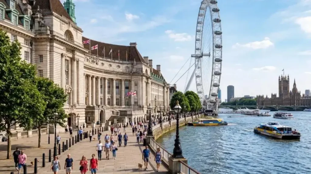
Waterloo and South Bank provide Lambeth’s strongest concentration of riverside culture, major attractions, pedestrian routes and transport connections. Visitors can combine the Thames, Queen’s Walk, cultural venues, Lower Marsh, Lambeth Palace and the Garden Museum in one compact itinerary.
South Bank occupies the riverside section of Lambeth opposite Westminster and the City of London. The area is internationally recognised for cultural institutions, public spaces and the Thames waterfront.
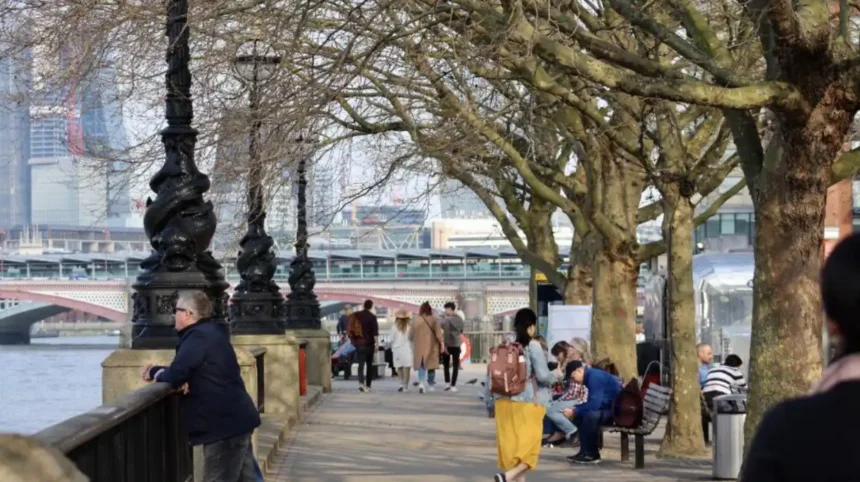
The Queen’s Walk provides a continuous pedestrian route along the river. Visit London describes the route as extending between Lambeth Bridge and Tower Bridge, linking numerous attractions and public spaces.
Visitors interested in heritage can include Lambeth Palace. The palace is the London residence of the Archbishop of Canterbury and is one of the few remaining medieval buildings in London. Guided visits include areas such as the Crypt, Guard Room, Chapel and Library, with advance booking required.
Nearby, the Garden Museum occupies the former St Mary-at-Lambeth church beside Lambeth Palace. It is Britain’s museum dedicated to the art, history and design of gardens. Its collections cover British gardening from the sixteenth century to the present.
The museum is also highly accessible from surrounding transport hubs. It is approximately a ten-minute walk from Lambeth North and around 15 minutes from Vauxhall. Waterloo is approximately 20 minutes away on foot.
Lower Marsh provides a different experience from the riverside attractions. It is a long-established local shopping street close to Waterloo Station. Visitors can use it to experience the everyday commercial character of Waterloo rather than remaining solely around major attractions.
Waterloo is also undergoing significant regeneration. Lambeth Council identifies future investment in public spaces, transport movement, Lower Marsh and surrounding areas, alongside plans associated with additional homes and jobs.
What can visitors see around Kennington, Oval and Vauxhall?
Kennington, Oval and Vauxhall combine royal and political heritage, cricket, riverside regeneration, historic streets and major transport links. Visitors can explore the three areas together because they sit close to the Thames and central London while retaining distinct local identities.
Kennington is one of Lambeth’s important historic neighbourhoods. Its location between central London, Elephant and Castle, Vauxhall and Brixton makes it useful as a transition point between northern and southern Lambeth.
The Oval is closely associated with The Kia Oval cricket ground, home of Surrey County Cricket Club. The stadium gives the neighbourhood a major sporting identity and provides a landmark for visitors exploring the surrounding streets.
Vauxhall sits beside the Thames and has developed into a major residential, commercial and transport district. Lambeth Council identifies Vauxhall as one of the borough’s major regeneration areas, with plans focused on homes, employment, greener streets, walking, cycling and stronger connections to the river and parks.
The Kennington, Oval and Vauxhall area also has an adopted neighbourhood plan. Lambeth Council formally adopted the plan on 23 January 2026 after the neighbourhood referendum held in December 2025.
This is significant for visitors because the area is changing while retaining its historic structure. New development sits alongside established streets, public squares, sporting facilities and historic buildings.
A practical exploration starts at Vauxhall Station, continues towards Vauxhall Pleasure Gardens, heads east towards Kennington and Oval, and then connects southwards towards Brixton or Stockwell.
As you explore the modern streets, you are crossing land with a deep heritage. Read about the full [Insert Anchor Text for History Article Here] to understand its origins.
How can visitors experience Brixton beyond the famous market?
Brixton combines food, music, migration history, independent businesses, public art, green space and strong community identity. Visitors should explore Brixton Village and Market Row, surrounding high streets, Windrush Square, Brixton’s cultural venues and nearby Brockwell Park.
Brixton is one of Lambeth’s best-known neighbourhoods and functions as a major commercial and cultural centre in South London.
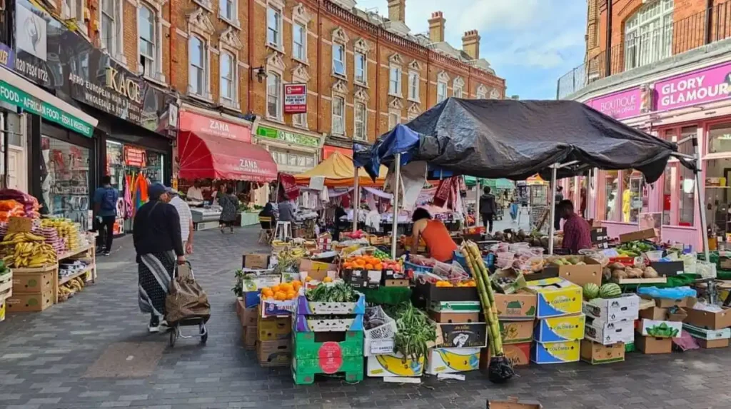
Brixton Market and the surrounding market areas provide a particularly strong introduction to the neighbourhood. Visitors can find food businesses, independent retailers and specialist shops reflecting the area’s international character.
Brixton’s cultural identity is also closely connected to the Windrush generation. The term “Windrush generation” refers to Caribbean people who arrived in Britain between 1948 and the early 1970s, including people who travelled on the HMT Empire Windrush in 1948.
Windrush Square provides a central public space associated with this history. The area also connects Brixton’s commercial centre with cultural and civic institutions.
Music forms another major part of Brixton’s identity. The neighbourhood has a long association with live music and venues, including the O2 Academy Brixton. Its cultural significance extends beyond individual performances because music is embedded in the area’s wider commercial and community history.
Visitors should also explore Brixton’s quieter streets rather than remaining around the market. Residential roads, independent cafés, community spaces and local businesses reveal a different side of the neighbourhood.
Brixton is also an effective base for reaching Brockwell Park and Herne Hill. The park provides open space, sports facilities and long walking routes. A neighbourhood itinerary therefore works best when it combines the busy central district with nearby green space.
Lambeth Council continues to treat Brixton as a major regeneration area. Its current planning framework recognises Brixton as one of the borough’s principal neighbourhood areas.
What should visitors explore in Stockwell and Myatt’s Fields?
Stockwell and Myatt’s Fields offer a quieter alternative to central Brixton, with residential streets, local shops, green spaces and strong transport connections. Visitors can use Stockwell as a walking link between Vauxhall, Clapham, Brixton and Kennington.
Stockwell sits centrally within Lambeth and has excellent Underground connections through Stockwell Station. The Northern and Victoria lines provide direct access to several parts of London.
Its location makes Stockwell particularly useful for visitors staying in South London. The neighbourhood connects naturally with Vauxhall to the north, Clapham to the west and Brixton to the south-east.
Stockwell’s residential character is important. The area includes Victorian and Edwardian housing, converted properties, local shops and community facilities. The streets around Larkhall provide another distinct local environment, with independent businesses and neighbourhood-scale activity.
Myatt’s Fields Park provides a green destination between Stockwell and Brixton. It offers lawns, mature planting and recreational space within a densely built-up area.
Visitors interested in photography and architecture should walk away from the main transport corridors. The residential streets provide a clearer view of Lambeth’s housing history and the relationship between town centres and surrounding neighbourhoods.
Stockwell also works well for visitors who want a less concentrated itinerary. Instead of spending the entire day in a major attraction district, travellers can use the neighbourhood as part of a walking route linking several areas.
Why is Clapham a good neighbourhood for parks and local life?
Clapham is particularly suitable for visitors seeking a combination of open green space, cafés, independent businesses, historic streets and transport connections. Clapham Common forms its main outdoor attraction, while Clapham High Street and nearby streets provide a busy neighbourhood centre.
Clapham is divided across several local administrative areas, including Clapham Town, Clapham East, Clapham Common and Abbeville, and Clapham Park.
The neighbourhood is strongly associated with Clapham Common. The common provides a large open landscape surrounded by dense urban development. It is suitable for walking, informal recreation and observing the contrast between green space and residential London.
Clapham Old Town provides a more historic streetscape. Its buildings, independent businesses and public spaces create a different environment from the modern commercial streets around Clapham High Street.
Clapham High Street is useful for visitors seeking cafés, restaurants, shops and evening activity. It also provides a transport corridor connecting the neighbourhood with Stockwell and Brixton.
The area works well as a half-day destination. Visitors can start around Clapham Common, continue through the Old Town, explore Clapham High Street and then travel towards Brixton or Stockwell.
Clapham also demonstrates how Lambeth combines local residential neighbourhoods with major public spaces. The common is not isolated from everyday life. It forms part of the area’s physical and social structure.
How can visitors discover Herne Hill and Tulse Hill?
Herne Hill and Tulse Hill provide a slower-paced southern Lambeth experience centred on local high streets, residential architecture, parks and community spaces. Visitors can combine Herne Hill with Brockwell Park and continue towards Brixton, West Norwood or Dulwich.
Herne Hill sits between Brixton, Dulwich and Tulse Hill. Its location gives visitors access to several different neighbourhood environments within a relatively short distance.
Herne Hill’s railway station provides a useful transport connection, while the high street contains independent businesses, cafés, restaurants and local services.
Brockwell Park is the major green-space attraction. The park sits between Brixton, Herne Hill and Tulse Hill and provides extensive open areas for walking and recreation.
Brockwell Park also contains Brockwell Lido, a historic open-air swimming facility. The combination of parkland, sports facilities and surrounding neighbourhood streets makes this area useful for visitors who want outdoor activities alongside local shopping.
Tulse Hill provides a more residential environment. The area includes streets of twentieth-century housing, local shops and connections towards West Norwood.
The contrast between Herne Hill and Tulse Hill demonstrates why neighbourhood exploration is more useful than simply following a list of famous attractions. The areas are close geographically but offer different urban environments.
Visitors can walk between Brixton, Brockwell Park, Herne Hill and Tulse Hill, creating a south London route that combines markets, green space, architecture and local businesses.
What makes Streatham different from central Lambeth?
Streatham provides a larger suburban-style town centre, extensive local shopping, green spaces and a strong residential character. Visitors can explore Streatham High Road, Streatham Common, Streatham Hill and nearby independent businesses for a different view of Lambeth.
Streatham occupies a large area in southern Lambeth and includes neighbourhoods such as Streatham Hill, Streatham Wells, Streatham St Leonard’s and Streatham Common and Vale.
Streatham High Road is the main commercial spine. It contains shops, restaurants, cafés, services and entertainment venues. Its scale gives Streatham a different character from the more compact commercial districts of Brixton or Stockwell.
Streatham Common provides an important open space at the southern end of the neighbourhood. The common contains grassland, mature trees and recreational areas and forms a natural transition towards the surrounding suburban districts.
Streatham Hill sits north of the main Streatham centre and connects towards Balham and Clapham. Visitors interested in architecture can explore the residential streets surrounding the high road.
Streatham is particularly suitable for travellers who have already visited central Lambeth and want to understand its southern edge. The neighbourhood demonstrates how Lambeth changes from inner-city districts into more suburban environments.
Transport connections also make Streatham practical for independent exploration. Rail and bus services link the area with central London and other parts of South London.
How should visitors explore West Norwood, Gipsy Hill and Knight’s Hill?
West Norwood, Gipsy Hill and Knight’s Hill provide a southern Lambeth experience built around local high streets, parks, Victorian and Edwardian housing, railway connections and views towards surrounding South London districts. They work best as a walking-focused neighbourhood itinerary.
West Norwood is one of Lambeth’s southern neighbourhood centres. Its high street provides everyday shopping, cafés, restaurants and local services.
West Norwood Cemetery is an important heritage site and forms part of London’s historic “Magnificent Seven” cemetery network. Its landscaped grounds contain numerous historic monuments and graves.
Gipsy Hill sits further south-east and is known for its elevated position and connections towards Crystal Palace. The area has a local high street, independent businesses and residential streets.
Knight’s Hill forms part of southern Lambeth and connects West Norwood with surrounding neighbourhoods. Its location makes it suitable for visitors exploring Lambeth beyond the main tourist circuit.
The southern neighbourhoods also provide useful routes into neighbouring parts of South London. Visitors can continue towards Dulwich, Crystal Palace or Norbury depending on their itinerary.
Lambeth Council’s neighbourhood framework groups Norwood as a major neighbourhood area containing St Martin’s, West Dulwich, Knight’s Hill and Gipsy Hill.
These areas are particularly useful for visitors interested in architecture, local history and everyday urban life rather than major central-London attractions.
What is the best way to travel between Lambeth’s neighbourhoods?
Walking, Underground services, National Rail, buses and cycling provide the main ways to connect Lambeth’s neighbourhoods. The most effective strategy is to combine walking within each area with public transport between districts that are farther apart.
Lambeth has an extensive transport network. Waterloo, Vauxhall, Stockwell, Brixton and other stations provide rapid connections to central London and surrounding areas.
Walking is especially effective between neighbouring districts. Waterloo connects naturally with South Bank and Lambeth Palace. Vauxhall connects with Kennington. Stockwell connects with Clapham and Brixton. Brixton connects with Herne Hill and Brockwell Park.
Cycling also provides a practical way to cross larger distances. Lambeth Council’s Healthy Streets mapping identifies cycle routes, cycle-hire docking stations, the Capital Ring, Jubilee Greenway and other walking and cycling infrastructure across the borough.
The Capital Ring is particularly useful for visitors who want a longer walking experience. It is a strategic walking route around inner and outer London and passes through several Lambeth neighbourhoods and nearby districts.
Visitors should also consider buses for cross-borough journeys. Bus routes provide connections where Underground lines do not follow the most direct neighbourhood-to-neighbourhood route.
The best method depends on the distance. Walking works well for nearby areas, public transport works efficiently for longer journeys, and cycling provides a flexible option for travellers comfortable with London traffic conditions.
How can visitors create a one-day Lambeth neighbourhood itinerary?
A one-day itinerary works best when visitors group nearby neighbourhoods instead of crossing the borough repeatedly. A northern route can cover Waterloo, South Bank, Lambeth Palace and Vauxhall, while a southern route can focus on Brixton, Herne Hill and Brockwell Park.
A northern itinerary can begin at Waterloo Station. Visitors can walk towards the Thames, follow Queen’s Walk, visit cultural attractions and continue towards Lambeth Palace and the Garden Museum.
The Garden Museum is particularly convenient because it sits close to several transport stations. Its current visitor information identifies Lambeth North, Vauxhall and Waterloo as nearby stations.
The route can continue south towards Vauxhall and Kennington. Visitors interested in sport can include The Oval before travelling towards Brixton.
A central itinerary can start in Brixton. Visitors can explore the market district, Windrush Square and surrounding streets before walking towards Brockwell Park and Herne Hill.
A southern itinerary can begin in Streatham and continue towards West Norwood or Gipsy Hill. This route focuses more strongly on local high streets, green spaces, residential architecture and heritage sites.
Visitors with two days have more flexibility. The first day can focus on North Lambeth and the Thames. The second can cover Brixton, Clapham, Herne Hill, Streatham or Norwood.
The key principle is geographical grouping. Exploring adjacent neighbourhoods reduces unnecessary travel and gives visitors enough time to notice differences in architecture, commerce, public space and local culture.
Explore More Area Guide
Best Leisure Days in Lambeth: Parks, Culture & Riverside South London 2026
Traditional London Experiences in Lambeth, South London 2026
How can visitors experience Lambeth as a local rather than only seeing major attractions?
Visitors experience Lambeth more fully by combining major landmarks with local high streets, parks, libraries, markets, independent businesses and residential streets. This approach reveals everyday life alongside the borough’s museums, cultural institutions, sporting venues and riverside attractions.
Major attractions provide an important introduction to Lambeth, but they do not represent the entire borough.
A neighbourhood-based visitor should spend time on local high streets. Brixton, Streatham, Clapham, Stockwell and West Norwood each have distinct commercial environments.
Markets are also important. Brixton’s market district provides a particularly strong example of Lambeth’s food and retail diversity.
Public libraries offer another way to understand local communities. Lambeth libraries provide events, free computer access and digital resources, while Lambeth Archives holds extensive local records and collections.
Lambeth Archives is especially valuable for visitors interested in local history. Its collections cover subjects including archaeology, architecture, Black history, LGBTQ+ history, social history, transport and women’s history. The archive collections extend back to the sixteenth century.
Parks provide another way to experience neighbourhood life. Clapham Common, Brockwell Park, Streatham Common and smaller local green spaces connect residential communities with outdoor recreation.
Visitors should also pay attention to the transition between neighbourhoods. A high street can change gradually into residential roads, which then connect with a park or railway station. These transitions show how Lambeth has developed as a collection of interconnected communities.
Why is neighbourhood-based exploration important for understanding Lambeth?
Neighbourhood-based exploration shows how Lambeth combines riverside London, historic districts, multicultural town centres, residential communities, green spaces and regeneration areas within one borough. It gives visitors a structured way to understand Lambeth geographically, historically and culturally.
Lambeth’s identity comes from its variety. The borough contains internationally recognised attractions beside local high streets and residential communities.
The official planning framework recognises this diversity through neighbourhood areas including Waterloo and South Bank, Kennington, Vauxhall, Stockwell, Clapham, Brixton, Streatham and Norwood.
This structure also continues to evolve. Lambeth’s Local Plan 2021 establishes policies covering housing, business, town centres, transport, environmental infrastructure and places and neighbourhoods for the 2020–2035 period.
Regeneration is particularly important in Waterloo and Vauxhall. New homes, jobs, public-realm improvements and transport changes are reshaping parts of these neighbourhoods.
For visitors, the implication is clear. Lambeth should not be treated as a single attraction zone. Its neighbourhoods provide different reasons to visit and different ways to spend time.
The most effective exploration strategy is therefore simple: choose a cluster of nearby neighbourhoods, walk between attractions, use public transport for longer connections, and combine major landmarks with local streets and green spaces.
A visitor who follows this approach can experience South Bank’s riverside culture, Kennington’s heritage, Vauxhall’s regeneration, Brixton’s markets and music, Clapham’s open spaces, Herne Hill’s local character, Streatham’s town centre and Norwood’s southern landscape as parts of one connected borough.
Lambeth’s neighbourhoods are close enough to combine but distinctive enough to reward separate exploration. That combination makes neighbourhood-based travel one of the most effective ways to understand South London.
What are the main neighbourhoods to explore in Lambeth?
Lambeth includes several distinctive neighbourhoods, including Waterloo and South Bank, Vauxhall, Kennington, Stockwell, Brixton, Clapham, Herne Hill, Tulse Hill, Streatham, West Norwood and Gipsy Hill. Each area has different attractions, parks, shopping streets, architecture and cultural experiences.